ROCKINGHAM COUNTY GOVERNMENT:
https://www.rockinghamcountync.gov/
COUNTY SEAT: Wentworth
FORMED:1785
FORMED FROM: Guilford
LAND AREA: 565.55 square miles
2020 POPULATION ESTIMATE: 91,096
White: 77.5%
Black/African American: 19.0%
American Indian: 0.6%
Asian: 0.7%
Pacific Islander: 0.1%
Two or more races: 2.1%
Hispanic/Latino: 6.3% (of any race)
From State & County QuickFacts, US Census Bureau, 2020.
CONGRESSIONAL DISTRICT: 6TH
BIOGRAPHIES FOR![]()
Rockingham County
 WILDLIFE PROFILES FOR
Piedmont region
GEOGRAPHIC INFORMATION
REGION: Piedmont
RIVER BASIN: Roanoke, Cape Fear, Map
NEIGHBORING COUNTIES: Caswell, Guilford, Stokes
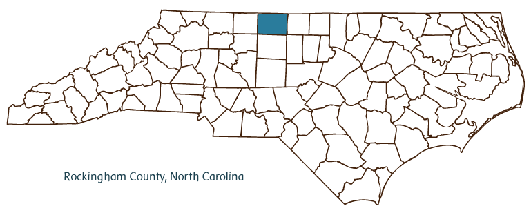
Rockingham County, located in the Piedmont region of North Carolina, was formed in 1785 from Guilford County and named for Charles Watson-Wentworth, second marquis of Rockingham, the British prime minister at the time of the repeal of the Stamp Act and a supporter of American Independence. It is partially bordered by the state of Virginia. Early inhabitants of the area included the Saura (Cheraw) Indians, followed by English, Scotch-Irish, and German settlers. Wentworth, the county seat, has the same namesake as the county and was incorporated in 1799. Other communities in Rockingham County include Reidsville, Eden (formed in 1967 by the merger of Leaksville, Draper, and Spray), Madison, Ellisboro, Williamsburg, and Ruffin. The Dan and Mayo Rivers flow through the county, as do Beaver, Matrimony, Quaqua, and Lovelace Creeks, among others.
Rockingham County farms produce agricultural goods such as tobacco, corn, peaches, blueberries, apples, blackberries, strawberries, tomatoes, Christmas trees, beef cattle, swine, and horses. Manufactures include textiles, furniture, food products, bricks, carpets, draperies, tobacco products, and plastics.
Among Rockingham County historic sites are the Penn House, built in 1932; the D. F. King House, built in 1875; the Tallula A. Richardson House, built in 1890; the Wright Tavern, erected in 1816; and the Troublesome Creek Ironworks, a Revolutionary War facility. Cultural attractions include the Dan River Arts Market, the Community Concert Series, the Rockingham Community Theatre Guild, and the Rockingham Theatre, the first theater in the state that was built to show sound films. The county also hosts festivals such as Gatsby Day at Chinqua-Penn Plantation, Shiloh Air Show, Mayodan Homecoming Festival, Eden Apple Festival, and the Madison Fair. Rockingham County's 2004 population was estimated to be slightly more than 92,000.
Annotated history of Rockingham County's formation:
For an annotated history of the county's formation, with the laws affecting the county, boundary lines and changes, and other origin information, visit these references in The Formation of the North Carolina Counties (Corbitt, 2000), available online at North Carolina Digital Collections (note, there may be additional items of interest for the county not listed here):
County formation history: https://digital.ncdcr.gov/Documents/Detail/the-formation-of-the-north-ca...
Index entry for the county: https://digital.ncdcr.gov/Documents/Detail/the-formation-of-the-north-ca...
Additional resources:
Corbitt, David Leroy. 2000. The formation of the North Carolina counties, 1663-1943. https://digital.ncdcr.gov/Documents/Detail/the-formation-of-the-north-carolina-counties-1663-1943/3692099?item=4553233 (accessed June 20, 2017).
Rockingham County Government: https://www.rockinghamcountync.gov/
Reidsville Chamber of Commerce: https://www.reidsvillechamber.org/
Digital NC, Rockingham County: https://www.digitalnc.org/counties/rockingham-county/
North Carolina Digital Collections (explore by place, time period, format): https://digital.ncdcr.gov
Image credits:
Rudersdorf, Amy. 2010. "NC County Maps." Government & Heritage Library, State Library of North Carolina.
1 January 2006 | Powell, William S.