The Qualla Boundary is the official name for the Eastern Band of the Cherokee's home in western North Carolina. These 57,000 acres were officially surveyed and the boundaries of The Qualla Boundary were established in 1876. The tract's origins are from the alliance and efforts of the Cherokee people and William Holland Thomas. Thomas purchased lands for the Cherokee people under his name in the 1840s and 1850s following the forcible relocation of the Cherokee people during the Trail of Tears in 1838 and 1839. In 1866, the United States recognized the right of the Cherokee to own and control the lands. Ten years later, the land was surveyed and officially demarcated as Cherokee land, outside of federal and state government jurisdiction.
Between October 1838 and March 1839, the federal government forcibly removed the Cherokee people from their lands in Western North Carolina. About 11,000 Cherokee people were relocated due to the Indian Removal Act in what became known as the Trail of Tears. Some Cherokee remained in North Carolina, however, including many who hid in the Great Smoky Mountains. In addition to those who eluded internment and forced migration, some Cherokee were free to stay because of earlier treaties, including the Oconaluftee Cherokee under Chief Yonaguska. These individuals recruited Thomas to purchase land on their behalf, which he began doing in 1840.
William Holland Thomas owned three stores in Qualla Town and the surrounding areas by the late 1820s. Thomas worked and lived amongst the Cherokee people early in his life, thus, he had familiarity with the Cherokee language. He was also a close friend of Yonaguska and well respected and trusted by the Cherokee people. After the Trail of Tears, Thomas acted on behalf of the Cherokee and acquired lands focused around the Oconaluftee River and Soco Creek. Approximately 50,000 acres were purchased around Oconaluftee Creek, which constitutes the majority of the Qualla Boundary today.
Thomas struggled to gain official permission for the Oconaluftee Cherokee to remain in North Carolina, however. In 1866, the Eastern Band of Cherokee were formally granted freedom to live in North Carolina. Two years later, the Eastern Band of Cherokee were recognized as a separate entity from the Cherokee people living in Oklahoma. In 1874, a board of arbitrators appointed by the federal courts found that Thomas’s land purchases were on behalf of the Cherokee people and the lands were placed in a trust for the Cherokee tribe.
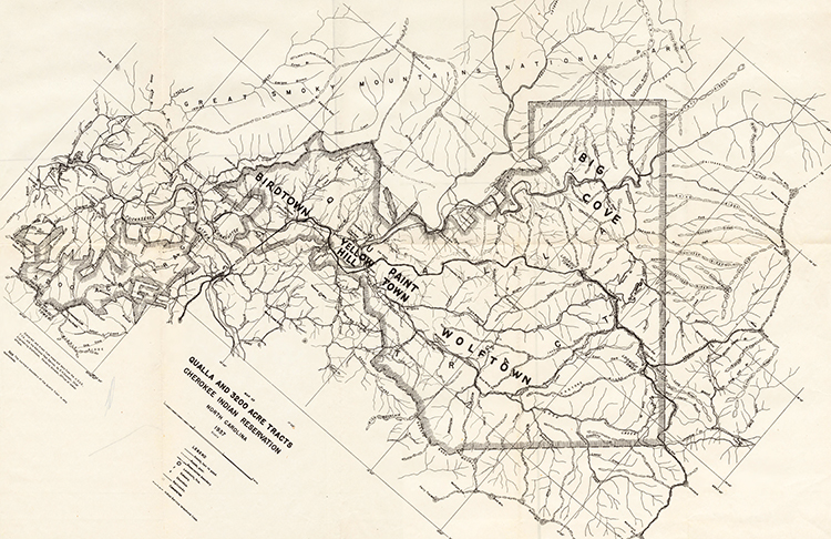
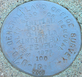
In 1876, a survey was completed by M. S. Temple, deputy U.S. Surveyor, because the boundaries of the land were still vague. The surveying began in Soco Gap, an area that was the most important passageway through the Balsam Mountains for the Cherokee before the arrival of the white settlers. The boundaries of the Qualla Boundary were established based off of this survey.