Transportation topics: Introduction | Highway use | Public transportation | Highway conditions | Water transportation | Air and rail travel | Projected future innovations
As shown in the NCpedia Web site chapter on Population, much of the state has continued to grow at a relatively rapid pace over the past two decades, and is expected to continue that trend into the future. The state as a whole increased its population 18.3 percent from 2000 to 2010, and by 2020 the population could again increase 14.2 percent. Earlier in this chapter, the amount of travel in the state was shown to have increased more than 30 percent between 2003 and 2007 in two of the state’s 100 counties. In 35 counties, traffic increased between 10 and 30 percent during that four-year period. Statewide, traffic has increased about 2 percent annually over the past decade.
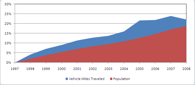
One of the more consistent factors that illustrates what many of our citizens often call “the transportation problem” is the rapid rate at which traffic has grown over the past several decades. An overriding concern of transportation officials at the state, regional, and local level in North Carolina is the continuing trend of vehicle travel increasing much faster than the increase in population. However, figure 27 shows that while the state’s population grew by approximately 19 percent from 1997 to 2008, the amount of Vehicle Miles Traveled on our highways grew by just a bit more, 22 percent. This illustrates that during this period efforts by the North Carolina Department of Transportation’s Division of Public Transportation to reduce growth in Vehicle Miles Traveled were effective. Still, growth is an issue that must be addressed with options that include strategies to decrease individual trips by single occupant motor vehicles. Solutions such as HOV (high occupancy vehicle) lanes, vanpools, and bus and rail transit need to grow more rapidly than these modes have in the past.
Congestion and safety issues on our highway system are expected to continue to be of major concern to citizens and public officials, as well as transportation professionals, for the foreseeable future. Much remains to be done to improve transportation systems. This section illustrates a sample of the role that innovations and new technologies will play in the further development of North Carolina’s transportation systems and services. A large number of innovations could be discussed, but only four are discussed here: (1) Passenger Rail, (2) Intelligent Transportation Systems, (3) Toll Roads and Bridges, and (4) Safety and Security.
The Future for Passenger Rail
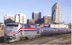
As North Carolina's population and traffic on its highways continue to grow, especially in the larger urban areas, the development of rail transportation becomes increasingly important as a choice for commuters and other travelers. The NCDOT has adopted a phased plan to extend intercity passenger rail service from its current routes to include a western route to Hickory and Asheville. The plan includes renovating or building train stations that will serve multiple uses and be attractive “urban hubs.” Much of the future of intercity and interstate passenger rail service is at best tenuous, however, based on the financial condition of Amtrak. Figure 28 shows one of the trains in current service.
Funding is yet to be provided for this extension, but the NCDOT and communities with potential for passenger rail continue to work on station renovations and rail safety improvements. Other studies currently being considered for future intercity passenger rail include service to Wilmington from Raleigh. In 2005, the Department released a study that detailed costs and improvements for re-establishing service to Southeastern North Carolina. The study recommended passenger rail service from Raleigh to Wilmington via Fayetteville and Goldsboro to be constructed in phases as funding becomes available.
In October 2002, the Federal Railroad Administration and Federal Highway Administration confirmed and approved a Southeast High Speed Rail Corridor through North Carolina and Virginia. Other possible passenger rail corridors are identified in Figure 26. These show both programmed and funded light rail service in Charlotte, as well as planned routes in the Triangle. The Triad’s regional transportation agency, PART, is currently assessing the potential for passenger rail in that region.
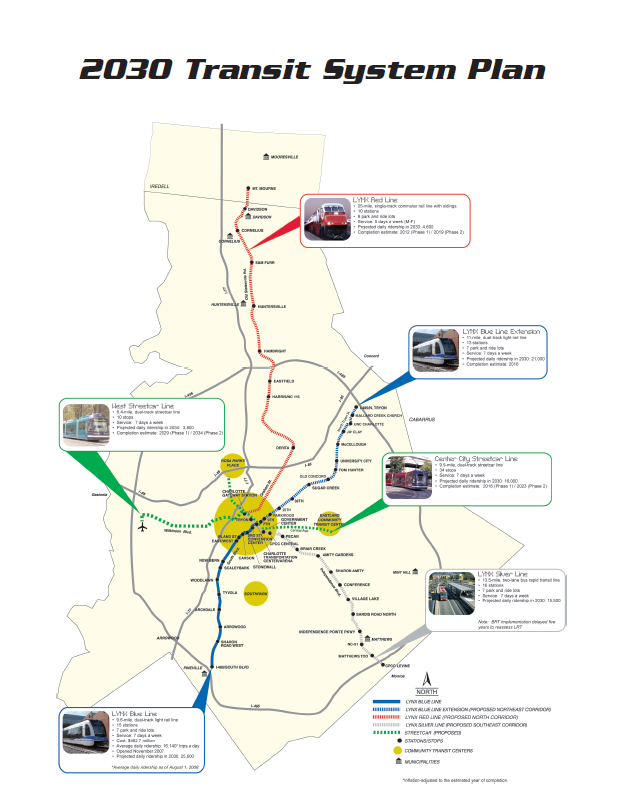
Regional passenger rail service is also under some stage of study or development in North Carolina’s three larger metropolitan areas, Charlotte, the Piedmont Triad, and the Research Triangle. The current status of these systems includes the completion of the South Corridor Light Rail Transit (LRT) project in Charlotte, now known as the LYNX Blue Line. The LYNX Blue Line is Charlotte’s first light rail service. It extends 9.6 miles from I-485 at South Boulevard to Uptown Charlotte. The dual track system generally operates within the existing railroad right-of-way paralleling South Boulevard. The system features 15 stations, seven of which are park-and-ride lots totaling over 3,600 parking spaces. Through the South End and Center City, light rail will share the tracks with the Historic Trolley, which is currently in operation. This is the first LRT system in operation in the state. As shown in Figure 29, Charlotte also has five additional corridors with passenger rail or other mass transit systems in various stages of planning or development.
In late 2003, the Major Investment Study for the Triad’s proposed passenger rail system was completed. Six years later, the Triad Alternatives Analysis report, which examined ways to improve regional connectivity and provide modal choice to the Piedmont Triad, was completed. The report recommended an East-West Corridor from Hanes Mall in Winston-Salem to North Carolina A&T State University in Greensboro as being the most cost-effective. Within the corridor, Bus Rapid Transit on an exclusive right-of-way and a rail alternative within existing railroads rights-of-way were recommended. However, the report’s findings could not be funded at this time.
In the Research Triangle area, the Triangle Transit Authority (TTA) signed a design and engineering agreement with United Transit Systems in May 2005 to begin building DMU rail vehicles for a 12-station, 28-mile Regional Rail Transit System between Durham, RTP, Cary and Raleigh. However, this project was stopped in 2006 after federal officials decided that there would not be enough riders to justify its costs. Currently, the TTA is collecting stakeholders’ opinions and previewing possible transit plans in a series of workshops around the Research Triangle. Under consideration are commuter trains between Garner and west Durham; a light rail line between northwest Cary and northeast Raleigh; a route involving light rail or bus rapid transit between downtown Durham and UNC Hospitals in Chapel Hill; and buses and downtown circulators or trolleys to serve future train stops.
Intelligent Transportation Systems
North Carolina has been one of approximately 35 states in the country to aggressively pursue innovative traffic operations solutions to increase the throughput and improve safety on its highway systems. These innovative solutions that apply technology to existing infrastructure without necessarily adding travel lanes are called Intelligent Transportation Systems, or ITS. The traveling public currently sees ITS more as a tool that is used only occasionally, such as emergency messages posted on electronic Changeable Message Boards that are apparent throughout the state. Some Changeable Message Boards are permanently mounted over the highway. Some are temporary, portable boards that are used primarily in construction zones. During the coming decades, however, more and more technology will be developed due to the coordination of traffic operations improvements by public agencies, both state and local, and the integration of those technologies in motor vehicles. The interchange of information between traffic control centers and motor vehicles will continue to develop in the future.
The following are examples of technologies and innovations expected to be implemented:
- Visibility Enhancement - Improved lighting systems on urban streets and highways, providing increased safety at night.
- Traffic Management – More flexibility in signal timing, more reliable controllers, and more of the highway system under traffic surveillance and control.
- Traffic Enforcement – Police departments in many cities and towns will take advantage of automated red-light running enforcement and speed measuring devices.
- Electronic Payment – North Carolina has recently established a State Highway Toll Authority to oversee the planning of pay-as-you-go toll roads and bridges and in-vehicle “tags” that electronically compile and bill for usage of the facility that will preclude the building of toll plazas and forcing vehicles to stop to pay tolls.
- Emergency Management – Geographic Information Systems (GIS)-based vehicle dispatch and Vehicle Location and Identification Systems will provide more efficient and quicker response by emergency vehicles to the scene of a highway or rail system crash or other incidents.
- Freight Management – A limited number of “Weigh-in-Motion” systems are in place in North Carolina at present, but these systems that allow trucks to be weighed and credentials checked electronically without stopping at a Weigh Station will come into increasing use in the future.
- In-vehicle Information Systems – Electronic devices are increasingly common in motor vehicles, such as vehicle location systems, engine monitoring, emergency notification, and collision avoidance systems, among others.
NCDOT’s Traffic Systems Operations Unit is deploying ITS strategically across the state’s ten Intelligent Transportation Systems Regions according to the Strategic Development Plan for each region, which altogether make up the statewide Intelligent Transportation Systems Strategic Deployment Plan. The goal of the Plan, according to NCDOT, “is to support the Department’s mission to provide and support an integrated transportation system and related services that enhance the State’s well-being.” The Plan also has eight objectives that ITS helps to fulfill to meet the goals of NCDOT:
- Use ITS technologies to provide information among modes of routes, schedules, incidents, fares, real-time vehicle tracking, and other traveler and shipper information.
- Use advanced technologies available in ITS solutions to provide “user friendly” interface between users and transportation systems and services.
- Investigate ITS technologies and applications in appropriate projects to provide innovative and flexible solutions and incorporate those technologies where cost-benefit ratios are greater than other solutions.
- Compare ITS solutions to new capacity solutions in order to obtain the most cost-effective use of available funding.
- Assess the environmental, energy consumption, aesthetic, and other impacts of ITS technology deployment as compared to other transportation solutions.
- Incorporate the entire ITS stakeholder base into local community efforts to support sustainable community initiatives.
- Use the technological skills of communications and electronics engineers to upgrade the level of technical expertise in NCDOT and upgrade other disciplines with cross-training in ITS technology applications.
- Develop strong, effective partnerships within the various units of NCDOT.
Toll Roads and Bridges
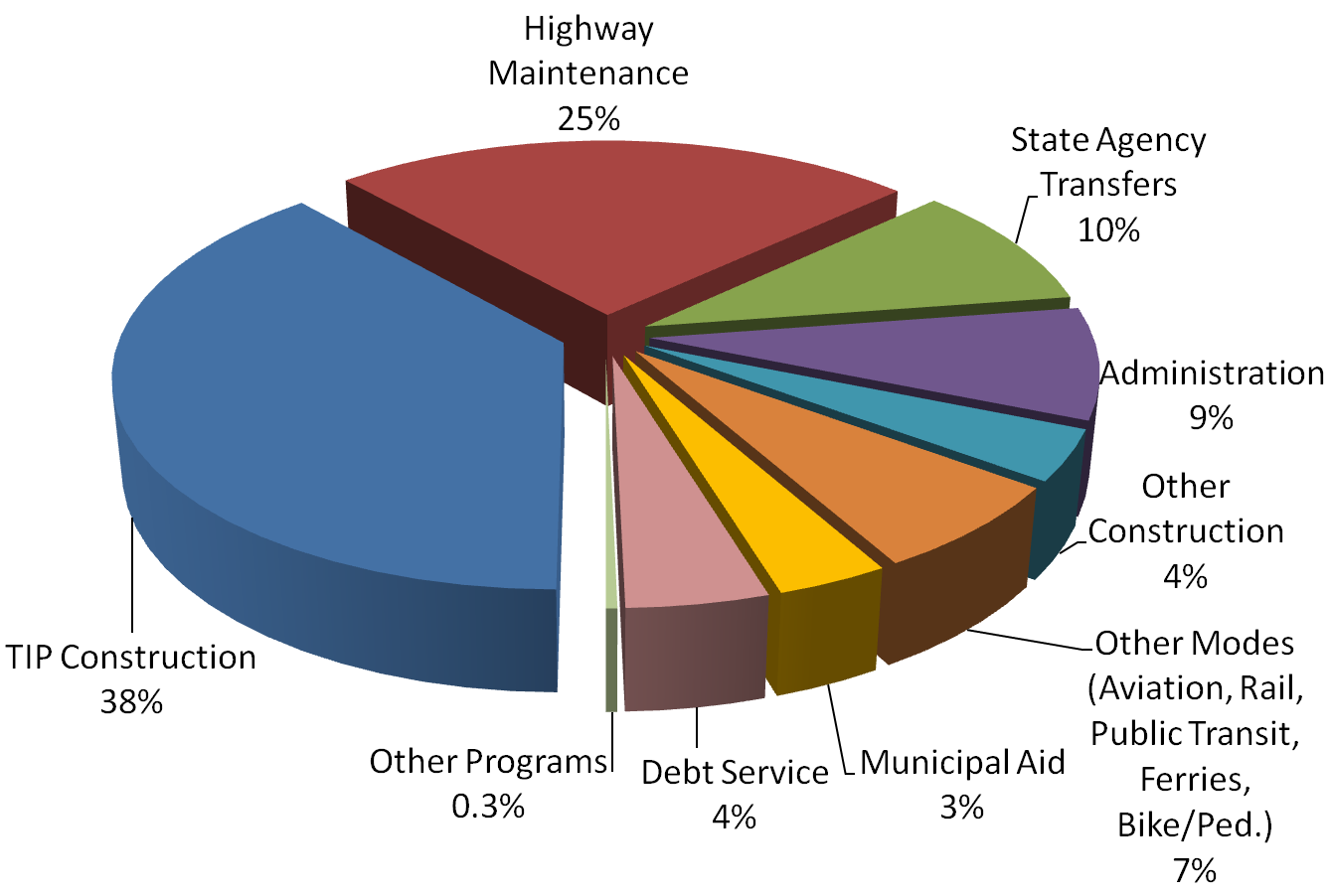
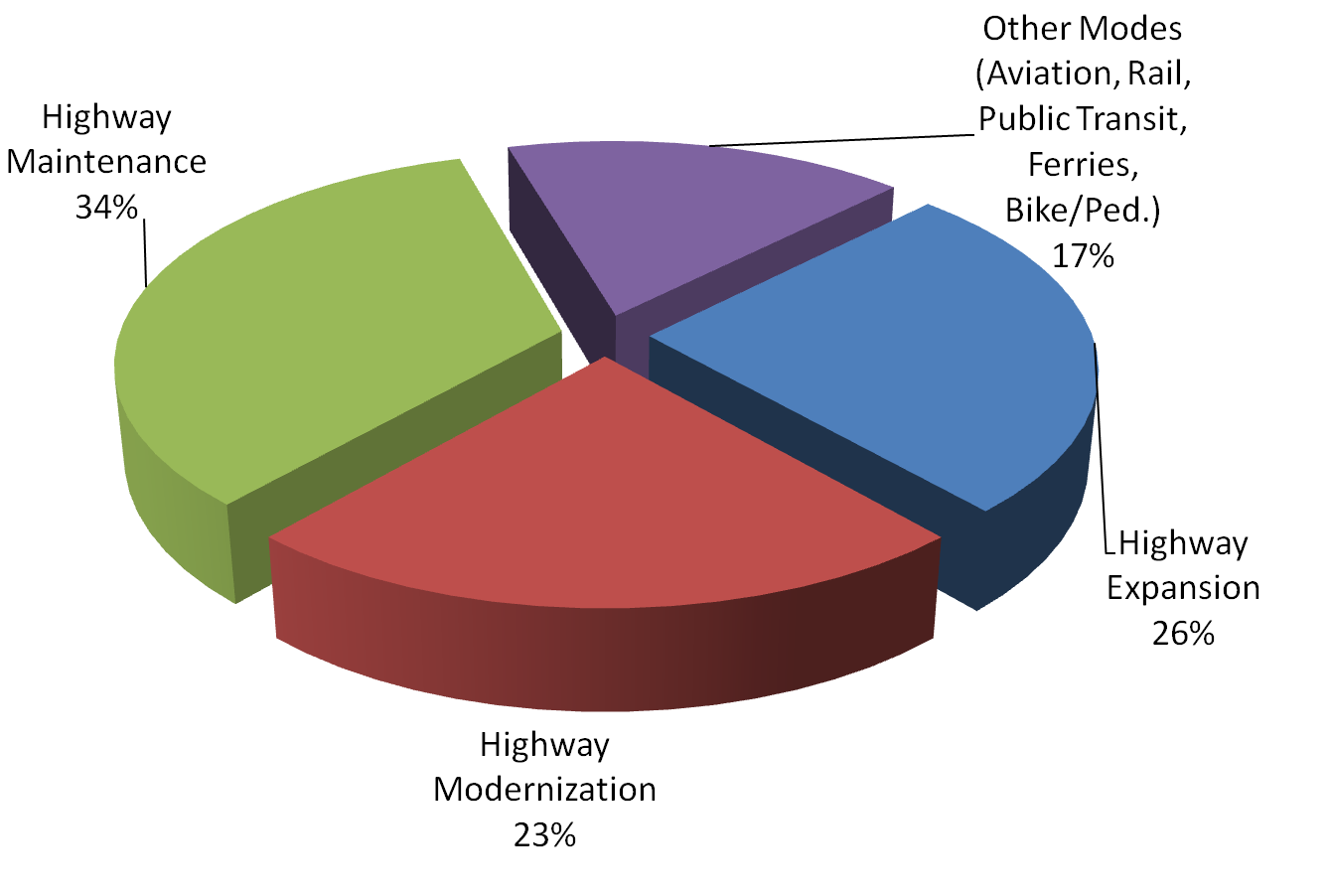
A number of innovative funding strategies are currently under study by the NCDOT, Metropolitan Planning Organizations (MPOs), and local governments across the state, with encouragement and sometimes special funding through the Federal Highway Administration (FHA). In late 2004, the North Carolina Board of Transportation adopted a long-range (25-year), multimodal transportation plan that included a “Recommended Investment Scenario.” This recommended guidance for the current and future Boards would shift funding priorities from highway expansion-type projects to more funding for highway maintenance and preservation, highway modernization (e.g., ITS), and other programmed improvements such as transit, rail, ferry, and bike/pedestrian projects. Other possible funding innovations that are on the horizon for the state’s transportation system include toll roads and bridges and “value pricing” approaches to paying for urban highways.
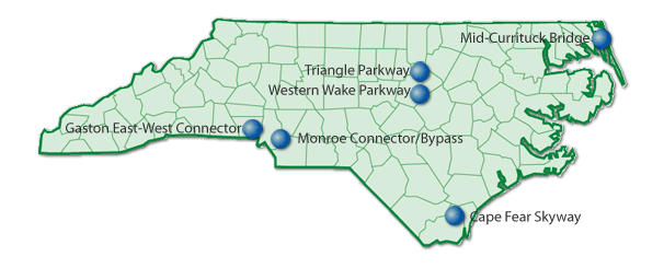
The North Carolina Turnpike Authority was established by the North Carolina General Assembly in October 2002. The charter for the Turnpike Authority (which is the first toll facility authority authorized in the past century in North Carolina) will plan, design, construct, operate, and maintain such toll facilities. The Authority is made up of nine members, with two each appointed by the Senate President Pro-Tem and the House Speaker and five more by the Governor (one of whom is the Secretary of Transportation). The concept behind these toll facilities is to offer motorists living or traveling in congested areas a choice of paying a premium for time savings and convenience. Six projects that have been authorized for study are shown in Figure 31. The Cape Fear Skyway includes a bridge across the Cape Fear River; the Mid-Currituck Bridge will connect Currituck County across the sound to the northern portion of the Outer Banks. Two projects are expressway/parkway facilities, and two are new roadway connectors.
Improving Transportation Safety and Security
Safety and security will always be given top priority in planning and designing of transportation facilities. The state has set a goal of reducing the current fatality rate on highways from its current 1.6 fatalities per 100 million Vehicle Miles Traveled to 1.0, a laudable goal. In the “Post-9/11” world, in addition to traditional and innovative highway safety programs, transportation security has become an important element in the consideration of safety. One of the critical challenges as new transportation infrastructure is built -- particularly bridges, tunnels, and passenger rail systems, as well as airport expansion projects -- is the fact that transportation is vulnerable to attacks by terrorists and saboteurs. While current infrastructure for the most part was designed to serve a market economy and an open society, builders can no longer afford not to consider such factors as facility surveillance and “structural hardening” in designs.
Redundancies in communication and control systems are needed in order to make streets, rail lines, and air traffic control centers safer. Various measures such as “hacking” through the Internet are known to be able to render network links or terminals inoperable for long periods of time. Terrorists have announced their long-term goals to create enough physical damage and fear in our population to bring our country to an economic standstill. Not only aircraft and airports, but passenger trains and buses, freight trains carrying hazardous materials, ships and ferries, tunnels, bridges, and other systems must be designed and built to counter the possible threat of damage or destruction.
Beyond the current, publicly visible and controversial increased passenger screening carried out by the Transportation Security Administration at airports, other more innovative technologies have recently been authorized by Congress. In January 2004, a program that was designed to provide better screening of international visitors to the country was initiated. This program is called US-VISIT (Visitor and Immigrant Status Indicator Technology), and is intended to require all visitors from non-visa waiver countries to provide biometric identification (e.g., finger scans). Beginning in October 2004, all visitors from the 26 recognized visa waiver countries also are required to pass through the finger scan test. Each visitor must then be identified with the same technology upon leaving the country in the time allowed by their visa. All 165 land border Points of Entry on the Mexican and Canadian borders have devices to provide biometric identification.
Summary
The vision in North Carolina’s long-range, multimodal transportation plan, Charting a New Direction for NCDOT(September 2004), is identified as a future transportation system that consists of all transportation modes and facilities, linked together. The plan identified and evaluated a full spectrum of future transportation needs and potential solutions that would achieve the goal of a “seamless” transportation system. Further, this plan is not inconsistent with a vision for a future transportation system on a nationwide scale, as related in the document Vision 2050: An Integrated National Transportation Systemby the Federal Transportation Advisory Group, an independent body of experts formed by the National Science and Technology Council (February 2001). Similarly, a vision for the future application of innovative solutions to the nation’s transportation system was highlighted in 2006 in Critical Issues in Transportation published by the Transportation Research Board.
Figure 32 illustrates the balance in the funding of North Carolina’s transportation systems during recent years compared with the projected future. This chapter on Transportation has attempted to present some of the trends recently experienced in North Carolina’s modes of transportation, with the overall perspective that the various modes and services are part of a “system of systems” that together make an integrated whole.
The summary, therefore, and a “forecast” for North Carolina’s transportation future should include the following vision statements paraphrased from the national Vision 2050 document. North Carolina should:
- Build and maintain an integrated transportation system that can economically and efficiently move people and goods anywhere, anytime, and on time;
- Manage the transportation system to the extent that there would ultimately be no injuries nor fatalities resulting from crashes or other incidents on any part of the system; and
- Continually work toward implementing transportation options that help clean our environment and specifically, minimize noxious emissions, greenhouse gases, and noise,