 1199163600
All Rights Reserved
"All rights reserved" is a traditional copyright term that indicates that the copyright holder reserves for his/her/their own use all of the rights given to copyright owners under U.S. copyright law. Items that are included in NCpedia and/or ANCHOR with this rights statement appear by agreement or permission from the rights holder or the institution that holds the item. Click "Available at" to visit the website for the collection where the item appears for more information about the rights or specific uses allowed. For all other non-specified uses, please contact the copyright holder or item owner.
Citation
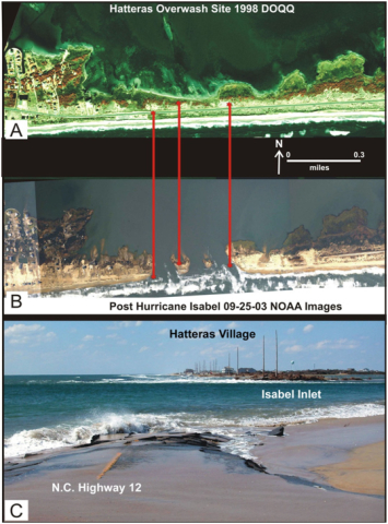
Riggs, Stanley R., Dorothea V. D. P. Ames, and North Carolina Sea Grant College Program. Drowning The North Carolina Coast : Sea-Level Rise And Estuarine Dynamics. pg, 141, Figure 8-4-18. Panel A. A 1998 DOQQ shows the location of the Hatteras Overwash site and location of the future Isabel Inlet (red stars).... Panel B. Post-Hurricane Isabel aerial photograph taken on 9/25/03.... Panel C. Photograph of Isabel Inlet taken on 9/29/03 shows NC Hwy. 12 “going-to-sea” with Hatteras Village in the distance. North Carolina Department of Environment and Natural Resources, December 2003. National Oceanic and Atmospheric Administration. Accessed February 20, 2026.