Currituck County Resources
- View All:
- Biographies
- Monuments
- locations
ANCHOR (A North Carolina History Online Resource) is now its own website!
Copyright Notice: This article is from the Encyclopedia of North Carolina edited by William S. Powell. Copyright © 2006 by the University of North Carolina Press. Used by permission of the publisher. For personal use and not for further distribution. Please submit permission requests for other use directly to the publisher.
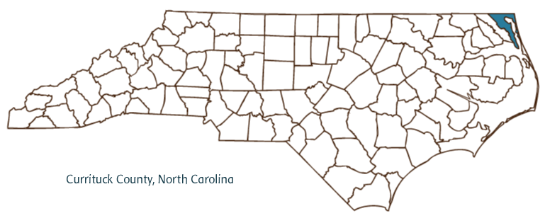
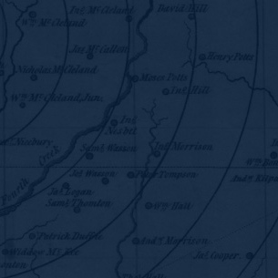
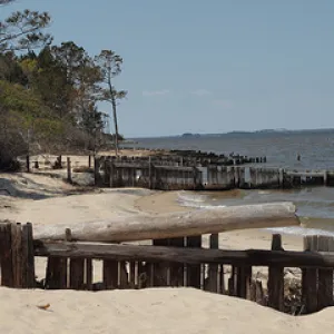
Currituck County, located in the Coastal Plain region of northeastern North Carolina, was formed in 1668, with its name taken from an Indian word meaning "land of the wild geese." It partially borders the state of Virginia and Currituck Sound, Albemarle Sound, and the Atlantic Ocean. The early inhabitants of the county were the Pasquotank Indians, followed by English and French Huguenot settlers. Currituck, the county seat, is named for the county. The town has never officially been incorporated, although it is mentioned in records dated as early as 1755. Other communities in Currituck County-all, like Currituck, unincorporated-include Corolla, Tulls Creek, Coinjock, Knotts Island, and Sligo.
Currituck County encompasses the northernmost section of the Outer Banks and is largely surrounded by bodies of water, which dominate its culture and economy. The county was home to one of North Carolina's first ports. It contains several wildlife sanctuaries, including the Currituck National Wildlife Refuge. It is also home to the largest population of "Banker" ponies, descendants of a breed of Spanish mustangs left by early explorers.
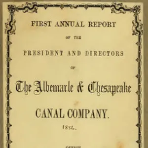
Currituck County agricultural products include potatoes, wheat, corn, strawberries, peanuts, soybeans, hay, swine, beef cattle, and chickens. It boasts a number of landmarks and historic sites, such as the Haywood Bell House, dating from before the American Revolution, and the Currituck Beach Lighthouse, constructed in 1875. The Albemarle and Chesapeake Canal, built between 1855 and 1859, bisects the county at its midpoint. County cultural institutions include the Currituck County Library. The county hosts several annual events, such as the Currituck Wildlife Festival, the Corolla Seafood Festival, and the Currituck County Resource Fair. In 2004 the population of Currituck County was estimated to be just under 22,000.
For an annotated history of the county's formation, with the laws affecting the county, boundary lines and changes, and other origin information, visit these references in The Formation of the North Carolina Counties (Corbitt, 2000), available online at North Carolina Digital Collections (note, there may be additional items of interest for the county not listed here):
County formation history: https://digital.ncdcr.gov/Documents/Detail/the-formation-of-the-north-ca...
Index entry for the county: https://digital.ncdcr.gov/Documents/Detail/the-formation-of-the-north-ca...
Additional resources:
Corbitt, David Leroy. 2000. The formation of the North Carolina counties, 1663-1943. https://digital.ncdcr.gov/Documents/Detail/the-formation-of-the-north-carolina-counties-1663-1943/3692099?item=4553233 (accessed June 20, 2017).
Currituck County Government: https://currituckcountync.gov/
Currituck County Chamber of Commerce: https://www.currituckchamber.org/
DigitalNC, Currituck County: https://www.digitalnc.org/counties/currituck-county/
North Carolina Digital Collections (explore by place, time period, format): https://digital.ncdcr.gov
Image credits:
Rudersdorf, Amy. 2010. "NC County Maps." Government & Heritage Library, Library of North Carolina.
Mazzocchi, Jay. "Currituck County." NCpedia. Library of NC. 2006.

CURRITUCK COUNTY GOVERNMENT:
https://currituckcountync.gov/
COUNTY SEAT: Currituck
FORMED: 1668
FORMED FROM: Albemarle
LAND AREA: 261.85 square miles
2020 POPULATION ESTIMATE: 28,100
White: 90.5%
Black/African American: 5.8%
American Indian: 0.7%
Asian: 0.8%
Pacific Islander: 0.1%
Two or more races: 2.1%
Hispanic/Latino: 4.4% (of any race)
From State & County QuickFacts, US Census Bureau, 2020.
CONGRESSIONAL DISTRICT: 3RD
BIOGRAPHIES FOR![]()
Currituck County
 WILDLIFE PROFILES FOR
Coastal Plain
GEOGRAPHIC INFORMATION
REGION: Coastal Plain
RIVER BASIN: Pasquotank, Map
NEIGHBORING COUNTIES: Camden, Dare