ANCHOR (A North Carolina History Online Resource) is now its own website!
NCpedia will be unavailable for about 1 hour starting at 4 pm this Friday, July 31. We apologize for any inconvenience.
Copyright Notice: This article is from the Encyclopedia of North Carolina edited by William S. Powell. Copyright © 2006 by the University of North Carolina Press. Used by permission of the publisher. For personal use and not for further distribution. Please submit permission requests for other use directly to the publisher.
References:
James H. Merrell, The Indians' New World: Catawbas and Their Neighbors from European Contact through the Era of Removal (1989).
Douglas L. Rights, The American Indian in North Carolina (1947).
Image Credit:
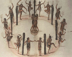
"Indians Dancing Around a Circle of Posts," watercolor by John White, created 1585-86." Image courtesy of the Trustees of the London Museum accessed via the Nation Park Service. Available from https://www.nps.gov/nr/travel/jamesriver/colonization.HTM (accessed May 23, 2012).
Green, Michael D. "Keyauwee Indians." NCpedia. Library of NC. 2006.