Printer-friendly page

Our State Geography in a Snap: The Piedmont Region

Reprinted with permission from the North Carolina Department of Public Instruction website.

See also:
Extended entry on the Piedmont (from NC Atlas Revisited)
Extended entry on the Piedmont (from the Encyclopedia of North Carolina)

Related Entries: Raleigh; Greensboro; Settlement of the Piedmont; Mountains; Coastal Plain; Regional Vegetation

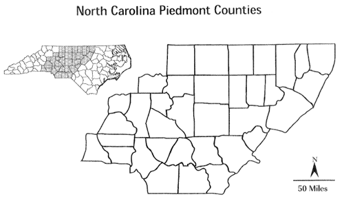
North Carolina Piedmont Counties

The Piedmont is the middle region of the state, located between the Coastal Plain and the Mountain regions. The name Piedmont comes from the Italian "pied" (foot) and "monte" (hill). The elevations of this region range from about 300 feet in the western Coastal Plain to about 1,500 feet near the mountains. The boundary between the Coastal Plain and the Piedmont is called the fall line or fall zone. Along this are, rivers flow from the older, harder rocks of the Piedmont to the softer rocks of the coastal Plain. Along the fall line, rivers form shoals, low waterfalls, and rapids. Below the fall line, streams are usually sluggish and smooth-flowing. Above the fall line, the streams are rocky and shallow, making boating difficult. The land of the Piedmont is called a plateau because it is high and mostly flat.


Sources:

National Geographic Society. “Piedmont.” National Geographic Society. National Geographic, October 9, 2012. https://www.nationalgeographic.org/encyclopedia/piedmont/.

"Social Studies:: Elementary Resouces:: Student Sampler:: Geography," North Carolina Department of Public Instruction Website. https://www.dpi.nc.gov/ (accessed March 27, 2012).

Video Credit:

"Scenic Flight: Fall Colors of North Carolina (Ashboro)," video courtesy Sprasad007, of uploaded on October 30, 2010, https://www.youtube.com/watch?v=QuPyeQZXRTI (accessed March 27, 2012).

Subjects: 
Authors: 
Origin - location: