See also: Blossom's Ferry.
Ferries are an integral part of North Carolina's modern transportation system, with 24 ferries providing regularly scheduled runs on seven different routes across rivers, sounds, and even an ocean access inlet. The capacity of the ferries in the state fleet ranges from 18 to 30 automobiles, and the one-way crossing time runs from 20 minutes on the Neuse River ferry between Minnesott Beach and Cherry Branch to 2 hours and 15 minutes on the voyage across Pamlico Sound from Ocracoke Island to Swan Quarter.
For tourists, a ferry ride is often a pleasant diversion from the routine of highway travel, but the ferries are essential to many coastal residents, providing access to and from work, school, and shopping centers. The Ocracoke-Swan Quarter ferry offers the only direct access from the isolated barrier island to the county seat on the mainland, and the modest fare charged for the service is considered a bargain. There is also a fee for the Ocracoke-to-Cedar Island run and for the Cape Fear River crossing from Southport to Fort Fisher. The other four routes-Currituck to Knotts Island, Bayview to Aurora, Minnesott Beach to Cherry Branch, and the Hatteras Inlet crossing from Hatteras to Ocracoke Island (the most frequently traveled route)-are free.
North Carolina entered the ferry business after World War II, when it bought out the Thomas A. Baum operations at Alligator River and Croatan Sound, the Toby Tillet ferries at Oregon Inlet, and Frazier Peele's Hatteras Inlet facilities. The current routes have evolved as bridges were built across Alligator River and Croatan Sound, and pressure for improved vehicular access resulted in the establishment of additional runs. The equipment and routes are new, but the use of ferries to enable people to cross the state's immense network of internal waterways dates back to the colonial period. In many instances, the only recourse available to early travelers was to ford the smaller streams in their paths; when it came to the larger watercourses, however, enterprising pioneers responded to the challenge with private ferries. Laws were passed requiring that each ferryman "secure a license from the county court, give bond for the faithful performance of his duty, provide . . . good and sufficient boats, and give constant attendance at the ferry," reported historian C. Christopher Crittenden, adding that "the rates were fixed for each ferry, varying with the length of the passage, the difficulty of crossing, and other similar factors."
A ferryboat design evolved gradually; it called for a craft of flat construction, preferably with sufficient capacity "to take in a carriage and four horses at once." Ferries were often undependable, especially after heavy rains when the freshets pouring down rivers made it impossible to use the cumbersome craft. Storms also affected ferry operations; Governor Arthur Dobbs, returning from a visit to Virginia in 1754, lost a full day at Edenton because the winds were so strong that the ferry could not cross Albemarle Sound. With a maze of rivers, creeks, and runs extending across the entire state, the use of ferries in the piedmont and mountains was just as important as it was in the lowlands. In 1771, while leading his army west, Governor William Tryon encountered Pole Cat Creek, which he described as being "too much swelled to pass over." Tryon had his men cut down a large tree, and they proceeded to cross over the makeshift little bridge "in Indian file."
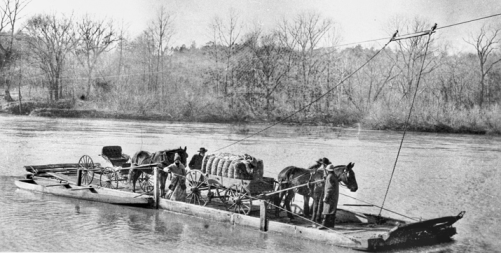
From the early kunners (vessels made of two or more dugout canoes lashed together) to the modern diesel ships that constitute the current state fleet, there have been many craft of innovative design operating in North Carolina as ferries. One unique craft was the cable ferry, introduced in the nineteenth century for use over narrow waterways; the Sans Souci cable ferry, which crosses the Cashie River in Bertie County, remained in operation in the early 2000s. Most unusual of all was the design Toby Tillet of Wanchese used in 1924 for his 2-car, 45-foot wooden ferry Oregon Inlet. Because the channels in the inlet and shoreline were forever in a state of flux, Tillet made no effort to establish any dock or permanent landing place on either the Bodie Island or Hatteras Island side. Instead, he put a landing ramp on the bow that could be raised or lowered by one man with the aid of chains and pulleys. When coming in for a landing, Tillet would ram the bow of his ferry against the shore at whatever he considered the best spot on that particular day, then lower the ramp and guide the drivers as they backed onto the sandy beach. The system proved so successful that Tillet continued to use it in the successively larger ferries he built for the Oregon Inlet run, the 10-car New Inlet and 14-car Barcelona. In a 1930s hurricane, the original ferry broke loose from its moorings, sailed pilotless out to sea, and was never recovered.
By the early 2000s, according to the North Carolina Department of Transportation's Ferry Division, North Carolina ferries were transporting more than 1.1 million vehicles and more than 2.5 million passengers annually.