Clay County Resources
- View All:
- Biographies
- Monuments
- locations
ANCHOR (A North Carolina History Online Resource) is now its own website!
Copyright Notice: This article is from the Encyclopedia of North Carolina edited by William S. Powell. Copyright © 2006 by the University of North Carolina Press. Used by permission of the publisher. For personal use and not for further distribution. Please submit permission requests for other use directly to the publisher.
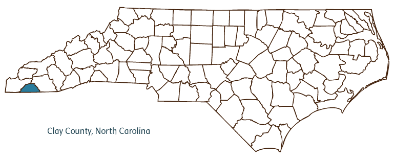
Clay County, located in the Mountain region of southwestern North Carolina, was formed from Cherokee County in 1861 and named for Henry Clay, a U.S. congressional leader and presidential candidate from Kentucky. It partially borders the state of Georgia. Early inhabitants of the area included the Cherokee Indians, followed by Scotch-Irish and English settlers. Hayesville, the county seat, was incorporated in 1891 and named for George W. Hayes, a member of the North Carolina General Assembly who worked for the formation of Clay County. The Nantahala National Forest covers a section of Clay County, and other notable physical features include the Hiwassee River, Jack Rabbit Mountain, Chunky Gal Mountain, Yellow Mountain, the Pinnacle, and Standing Indian Mountain.
Clay County prospers from a thriving tourism trade due to its rugged mountains, trout fishing, and crafts industry, centered on the John C. Campbell Folk School in Brasstown, founded in 1925. The school weds a Danish model of study with the cultural traditions of the region. The county's farms produce grain, tomatoes, vegetables, hay, poultry, swine, and beef and dairy cattle. Manufactured products include coaxial cables, textiles, trusses, and resistors for light fixtures.
Clay County has a number of historic landmarks, including the Pioneer Village in Tusquitee and the Clay County Courthouse (1889). Cultural institutions include the Clay County Art and Historical Museum and the Peacock Playhouse. The county also hosts several annual festivals and events, such as the Campbell Folk School Fall Festival and the Blacksmith Auction. In 2004 Clay County's population was estimated to be 9,600.
For an annotated history of the county's formation, with the laws affecting the county, boundary lines and changes, and other origin information, visit these references in The Formation of the North Carolina Counties (Corbitt, 2000), available online at North Carolina Digital Collections (note, there may be additional items of interest for the county not listed here):
County formation history: https://digital.ncdcr.gov/Documents/Detail/the-formation-of-the-north-ca...
Index entry for the county: https://digital.ncdcr.gov/Documents/Detail/the-formation-of-the-north-ca...
References:
J. Guy Padgett, History of Clay County (1977).
Additional resources:
Corbitt, David Leroy. 2000. The formation of the North Carolina counties, 1663-1943. https://digital.ncdcr.gov/Documents/Detail/the-formation-of-the-north-carolina-counties-1663-1943/3692099?item=4553233 (accessed June 20, 2017).
Clay County Government: https://www.clayconc.com/
Clay County Chamber of Commerce: https://www.claychambernc.com/
DigitalNC, Clay County: https://www.digitalnc.org/counties/clay-county/
North Carolina Digital Collections (explore by place, time period, format): https://digital.ncdcr.gov
Image credits:
Rudersdorf, Amy. 2010. "NC County Maps." Government & Heritage Library, Library of North Carolina.
Mazzocchi, Jay. "Clay County." NCpedia. Library of NC. 2006.
CLAY COUNTY GOVERNMENT:
https://www.clayconc.com/
COUNTY SEAT: Hayesville
FORMED: 1861
FORMED FROM: Cherokee
LAND AREA: 214.75 square miles
2020 POPULATION ESTIMATE: 11,089
White: 95.9%
Black/African American: 1.3%
American Indian: 0.7%
Asian: 0.4%
Pacific Islander: 0.1%
Two or more races: 1.6%
Hispanic/Latino: 3.9% (of any race)
From State & County QuickFacts, US Census Bureau, 2020.
CONGRESSIONAL DISTRICT: 11TH
BIOGRAPHIES FOR![]()
Clay County
 WILDLIFE PROFILES FOR
Mountain region
GEOGRAPHIC INFORMATION
REGION: Mountain
RIVER BASIN: Hiwassee, Map
NEIGHBORING COUNTIES: Cherokee, Macon