The State of Buncombe
Buncombe County was officially created in 1792. It was named after Revolutionary War hero Colonel Edward Buncombe of Tyrell County for political reasons. Called the "State of Buncombe," the county originally included present day Buncombe, Clay, Graham, Haywood, Henderson, Jackson, Macon, Madison, Swain, Transylvania and parts of Polk and Yancey Counties. On April 16, 1792, the first Buncombe County Court, which served as the County's governing body, met at the house of Colonel William Davidson at Gum Spring (near the present entrance to the Biltmore Estate). Justices were James Alexander, James Brittain, James Davidson, William Davidson, Philip Hoodenpile, David Vance (Clerk of Court), and William Whitson. The first order of business was for the men to remove their coonskin caps. The Court then filled public offices, including Thomas Davidson as entry officer of land claims and James Patton was surveyor. The Court also levied taxes and ordered William Davidson to build a gristmill on the Swannanoa, near his sawmill. In addition, the Court ordered several men to lay a road from William Davidson's to Benjamin David's (at Davidson's Creek). However, the commission could not agree on a location for the county seat. In December of 1792, the state legislature named a second commission to locate the county seat and to place a courthouse, jail, and stocks. In July 1793, the county seat was established as "Morristown" on a well-drained plateau where two old Indian trails crossed (today's Pack Square). The village was renamed Asheville in 1797 in honor of Governor Samuel Ash.
As the region developed, the need for roads increased. The first settlements had been loosely connected by existing Indian trails. Widening those Indian trails and building new roads was an important activity for the newly formed Buncombe County. The Court appointed an overseer and a work gang of men to build roads to link the communities. All male residents were required to spend a certain number of days each year on road building and maintenance. While no one was paid for this labor, the materials were donated. These work gangs became occasions of celebration, with shooting matches, lifting contests, and all the amusements of a frontier region. The work sometimes suffered from these diversions.
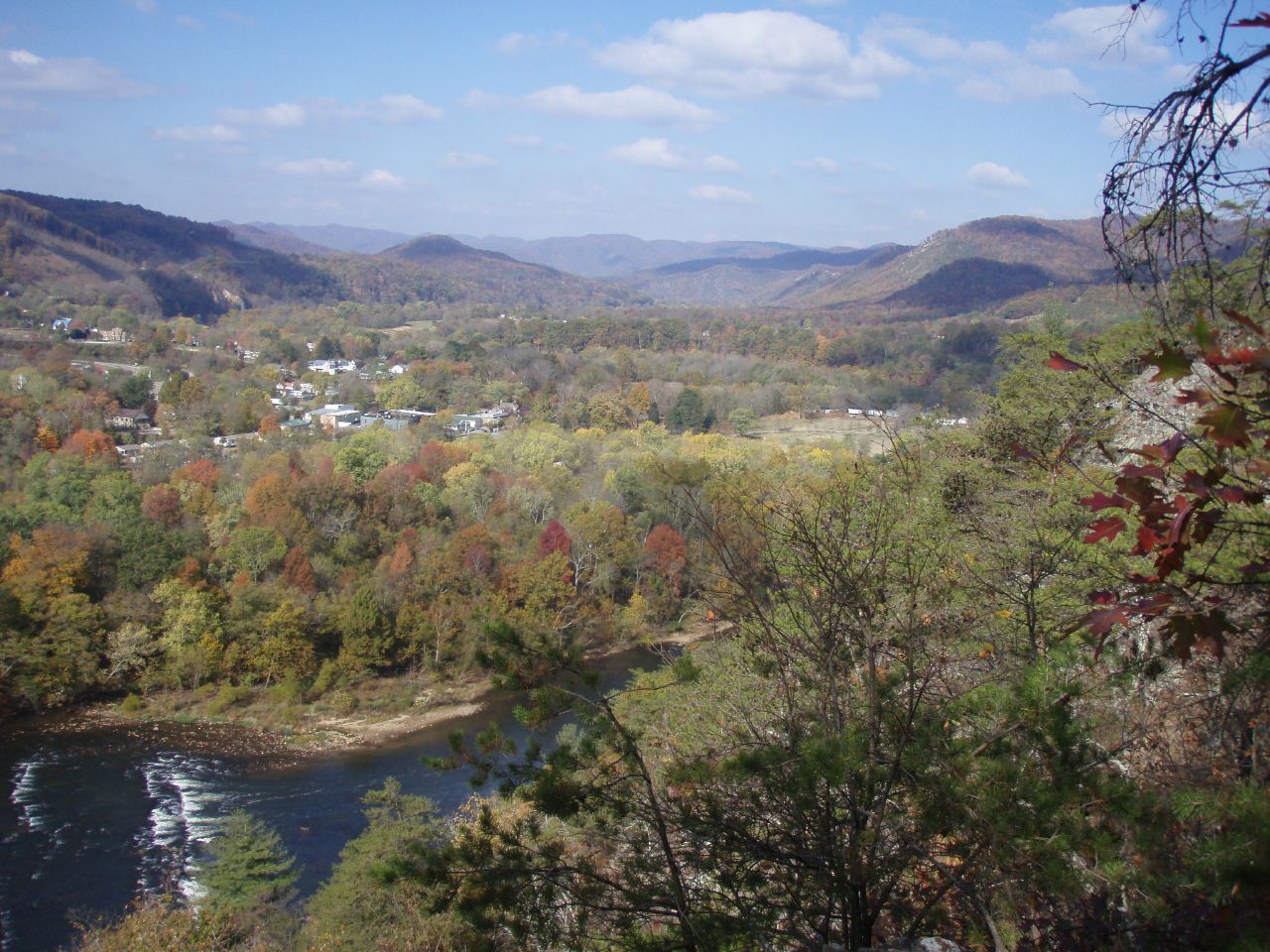
The early roads were dirt or gravel and were indicated by notches on marginal trees. First class roads required to be twelve feet wide and third class roads were supposed to be wide enough for a single horse and rider. On the fairly level Asheville plateau, the roads could go in nearly any direction, but where the mountains were higher, the roads had to follow the course of the streams and rivers. Along these stream gorges, the early roads were "fearful and wonderful things." In a five-mile stretch from mid-Asheville, the French Broad River's bed drops from 1,985 feet above sea level to 1,924 feet. Midway between the mouth of Reems Creek and Flat Creeks, its bed is at 1,785 feet. Although the new roads were crude, they made it possible to use wagons to go from settlement to settlement. Sondley reports that in July 1795, "Two wagons arrived at Knoxville from South Carolina, having passed through the mountains by way of Warm Springs of the French Broad; so a wagon road may be said to have been opened from Georgia, South Carolina and other Atlantic States." Francis Asbury, a Bishop in the Methodist Church who visited in the mountain region from 1800 to 1814, recorded his difficulties traveling in 1802. "We labored over the Ridge and the Paint Mountain; I held on awhile, but grew afraid and dismounted, and with the help of a pine sapling, worked by way down the steepest and roughest part." In coming through Mills Gap between Buncombe and Rutherford Counties in 1806, he wrote, "One of the descents in like the roof of a house, for nearly a mile… I road, I walked, I sweat, I tumbled, and my old knees failed. Here are gullies, and rocks, and precipices, …bad is the best." At the end of one of his annual visits, Asbury recorded, "Once more I have escaped from filth, fleas, rattlesnakes, hills, mountains, rocks, and rivers."
Even though roads were improved, river crossings were still a problem. Roads crossed rivers where fording was convenient, but this limited crossings and travel to periods of low water. Because of its size, the French Broad River could only be crossed using crude ferries of either canoes or flat boats that were pulled by ropes. By 1798, John Davis operated a ferry across the French Broad near the mouth of Newfound Creek. The county established rates for this ferry in 1801 as follows, "Waggons & Team and Driver 50 Cents; Two-Wheeled carriage and Team with Driver 25 cents; Man and Horse 6 cents; A footman 6 cents; All Kinds Loose Stock 2 Cents pr Head." A raft full of livestock must have been an incredible sight, and was probably a fairly dangerous endeavor.
The Drovers' Road
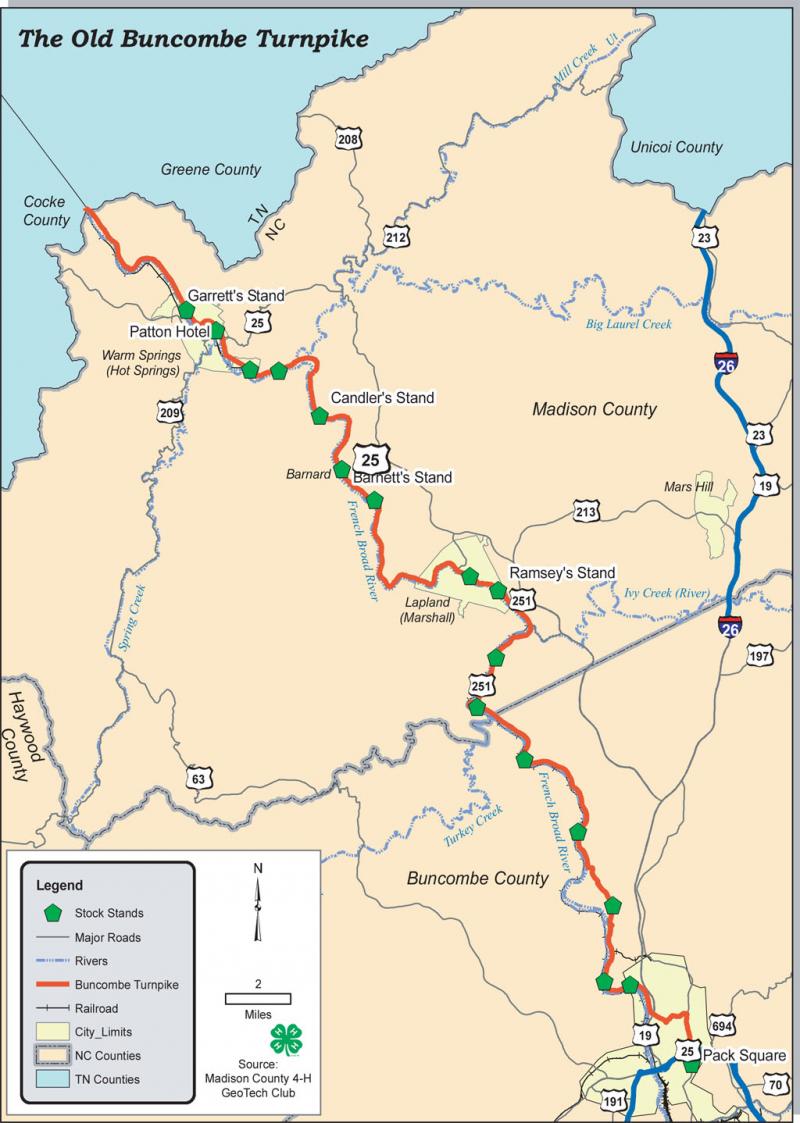
By the early nineteenth-century, these roads were heavily traveled by settlers who were moving west to claim new land. Their covered wagons come from the east through the Hickory Nut Gap (Sherill's Inn in Fairview was established along this route around 1801) and from the south through Saluda Gap. Because its rivers flowed west and not east, Western North Carolina had little benefit from trade with population centers to the south and east. However, the mountain region's Indian corn had a market in plantation country where the focus was on producing cash crops such as cotton, indigo, cane, and rice. In 1819, the North Carolina General Assembly created a Board of Internal Improvement and hired a state engineer to build roads in Western North Carolina. The plans included a road from Asheville to Charleston, South Carolina, and a turnpike (The Buncombe Turnpike) along the French Broad River that would connect with a road running from Greenville, Tennessee to Greeneville, South Carolina.
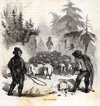
With the these improved roads, farmers from Western North Carolina, Tennessee, and Kentucky had an accessible way of getting their farm products to market, and could greatly increase their supplies and profit by transporting goods by wagons. However, the best way to market their corn was by feeding it to hogs, cattle, and turkeys. In late fall, farmers gathered their hogs, cattle, horses, mules, turkeys, or ducks for the trip to markets in Charleston, South Carolina and Augusta, Georgia. The roads were alive with livestock for the next two months. Men called drovers led these herds of animals to market. The drovers relied on helpers, usually young boys, to keep the animals moving by cracking whips tied with strips of red flannel. Depending on the type of livestock, drovers could travel six to twenty miles each day. Hogs, the most numerous animal on the turnpike, could only travel six to eight miles a day. Every eight or ten miles along the road, there would be a "stand" where animals could be fed and penned outdoors and the men could find hospitality indoors. Although this route was used by all sorts of traffic, it gradually received the named of the Drovers' Road.
The Buncombe Turnpike
In 1824, the legislature of North Carolina incorporated The Buncombe Turnpike Company under the control of James Patton, Samuel Chunn, and George Swain. The Company had an authorized capital stock of $50,000 at $50 a share. The initial work on the Turnpike Company included surveys of the land. By 1827, the Buncombe Turnpike was completed and was considered the finest road in North Carolina. The Turnpike led from the Poinsett Road on the state line, through the Saluda Gap, by way of Flat Rock and Hendersonville, across the Asheville plateau to the Buncombe County Courthouse in Asheville, down the gorge of the French Broad River to Warm Springs, and just north at Paint Rock where it joined the Tennessee Road. The entire road was seventy-five miles in length.
Travel from Kentucky and Tennessee over the Turnpike route to southern markets made it the most used road in Western North Carolina. All the territory within miles of the Turnpike benefited greatly and North Carolina entered upon a period of marvelous prosperity. However, the most immediate change was the massive increase in number of livestock through Asheville. It is estimated that 150,000 to 175,000 hogs passed through each October, November and December on their way to market, forming an almost continuous string of hogs from Tennessee to Asheville. The hogs brought prosperity to Buncombe County, but they also contributed to the decay of the roads. Buncombe native Governor Zebulon Vance wrote, "The rain continues to fall, and our streets are almost impassible with the mud and thousands upon thousands of hogs moving through the town adds to the general filthyness [sic] of everything around." Certainly, one of the most vivid images from Asheville's past continues to be that of herds of hogs roaming down the city's main street.
James Smith's Bridge
Like other enterprising businessmen, James Smith invested in the stock of the Buncombe Turnpike Company, buying several shares of stock in the 1820s. Smith also had the foresight to buy prime land near the Turnpike and along the French Broad River. The livestock not only had to travel the Drovers' Road and the Buncombe Turnpike, but also had to cross rivers. James Smith purchased and operated the main ferry that crossed the French Broad River near Asheville. In 1834, Smith replaced the ferry with a wooden toll bridge (just south of the present-day Smokey Mountain Parkway Bridge on Patton Avenue). Because this was the only bridge across the French Broad, Smith gained great wealth from his County chartered monopoly.
|
[bridge crossing toll category] |
If loaded |
If empty |
|---|---|---|
|
4 horse wagon |
50 cents |
37.5 cents |
|
3 horse wagon |
37 cents |
31.5 cents |
|
2 horse wagon |
31.5 cents |
25 cents |
|
1 horse wagon |
25 cents |
25 cents |
|
4 wheel carriage of pleasure |
50 cents |
50 cents |
|
Buggy of pleasure |
37.5 cents |
37.5 cents |
|
Gig of sulky of pleasure |
25 cents |
25 cents |
|
Cart |
25 cents |
25 cents |
|
Slide of truck |
12.5 cents |
12.5 cents |
|
Man and horse |
6.25 cents |
6.25 cents |
|
Loose horses or mules |
3 cents |
3 cents |
|
Footmen |
2 cents |
2 cents |
|
Cattle |
2 cents |
2 cents |
|
Sheep and hogs |
1 cent |
1 cent |
|
Turkey |
1/2 cent |
1/2 cent |
Smith's monopoly was threatened in 1844, when another bridge crossing the French Broad was proposed. He unsuccessfully petitioned against this bridge that was supposed to be free for the public. Smith continued to collect tolls until he sold his bridge to the County and it, too, became public. The wooden bridge was replaced by an iron bridge in 1881. The iron bridge was replaced by a reinforced concrete bridge after the flood of 1916. That bridge was closed in the 1970s and was, finally, replaced in the 1990s. Today, this low bridge is adjacent to the Smokey Mountain Parkway Bridge on Patton Avenue and connects to West Asheville.
Stands along the Turnpike
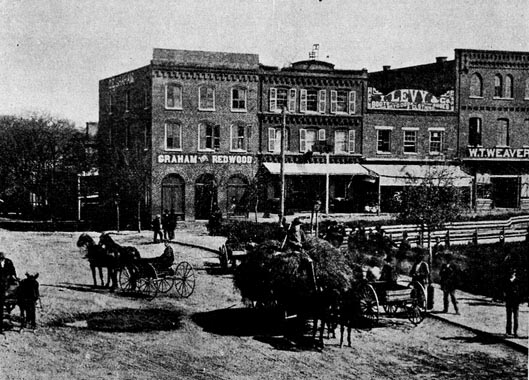
Toll roads and bridges weren't the only potential for income from the drovers. To accommodate the on-going traffic on the Turnpike, enterprising people established stands, or wayside inns with stockyards, every two to eight miles along the road. While long gone, the stands and their owners became synonymous with Buncombe County place names, including James Mitchell Alexander's (Alexander), Hezekiah Barnard's (Barnardsville), and Zachariah Candler's (Candler). The first "hotel" in Asheville was the Alexander. In 1814, James Patton opened a second hotel on Main Street, now Biltmore Avenue. Originally of frame construction, Patton's three-story Eagle Hotel was eventually enlarged by a brick addition and, thus, is often referred to as a brick hotel. The Eagle was advertised as a luxury hotel and probably was not used by many drovers. In 1825, James Smith built and managed a third hotel -- the Buck Hotel -- that catered to the drovers. The Buck Hotel, pictured here, was located on Main Street near the southeast side of Public Square, later the site of Langren Hotel and now the site of the BB&T building's parking garage that is across Biltmore Avenue from the BB&T building.
During the peak months of October, November and December, it was not uncommon for each stand or hotel to have as many as twelve droves, numbering anywhere between 300 to 2,000 animals, each night. The stands provided feed and shelter for livestock and a meal and rest for the drovers. The corn for livestock and the drover's hearty meal cost around $1.00, but a space to sleep on the floor of the "great room" was free; the drover provided his own blanket. If cash was short, drovers would pay on the return home or would leave livestock with the innkeepers.
While drovers used the Turnpike and stands during the fall and winter, stagecoaches began using the road shortly after the Turnpike opened. Stagecoaches ran on a regular schedule from Charleston to Greenville, South Carolina and from there to Asheville. These stagecoaches brought Asheville regular mail delivery, new fashions for local stores, and visitors from Charleston. By the 1830s, stagecoach travelers could go from Asheville to Nashville. There were fourteen routes out of Nashville, with connections to Asheville, New Orleans, Blountsville, Tennessee; and Athens and Calhoun in Georgia. One visitor wrote, "The turnpike road is excellent, the river beautiful, and the scenery on both sides wild and grant. The public houses too are good." Another wrote, "Our road, an excellent one for the mountains, is cut out along the very margin of the river. Occasionally there is no ledge to protect you from the steep. You wind along the precipice with a perpetual sense of danger, which increases the sublimity of the scene. The river, meanwhile, boils, and bounds, and rages at your feet…" Despite the risks of travel, Asheville quickly gained a reputation as a health resort, attracting summer residents from Charleston and Augusta who enjoyed the cool mountain air. The year the Turnpike was finished, Susan and Charles Baring built a home at Flat Rock, starting the "Little Charleston of the Mountains."
Impact of the Turnpike
The stock drives had a greater impact on the local economy then the early tourists. The greatest benefit to Buncombe farmers was the enormous demand for corn to feed the droves of animals. In 1828, Candler sold some 2,000 bushels of corn to hog drovers. Based on a diet of 24 bushels daily for each 1,000 hogs, Candler had fed around 80,000 hogs at his stand and, those drovers would have stopped elsewhere each day. New land was cleared to grow the corn that became the region's first "cash crop." This led to increased settlement along the roads, additional cleared land, and larger fields. For example, James Smith had some 350 cleared acres for planting at one of his farms. These larger plantations required more labor, marking an increase in slavery in the region.
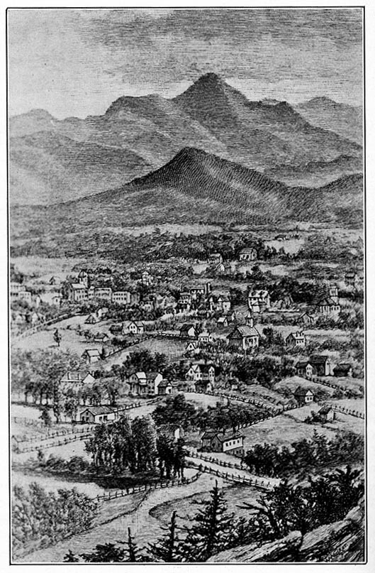
As Asheville's population grew, extravagant homes were built around the city. These new city residents increased the demand for skilled labor, many services were provided by slaves. The growing city also had expanding transportation needs. In 1851, a plank road, built with thick oak boards, was constructed from Asheville to Greenville, South Carolina where travelers could catch the train. Although the Old Plank Road lasted only around eight years, it provided mud-free travel to the Georgia line and to Salisbury in eastern North Carolina. A charter for a Western North Carolina Railroad was issued in 1855. Asheville's population jumped from 800 in 1850 to 1,100 in 1860. With two Buncombe County natives elected as Governor of North Carolina, Asheville was on the verge of becoming a center not just for Western North Carolina, but also for the State of North Carolina.
The Civil War and the arrival of the railroad
The Drovers' Road was not only the key to economic and social growth in the mountain section of North Carolina, but it also played a role in the Civil War. The network of roads provided easy travel for Union troops seeking food and shelter and provided former slaves and others passage to Tennessee to join the Union army. General George Stoneman's Raiders were able to gain entry to Asheville through the drovers' roads at Hickory Nut Gap in April of 1863. These Raiders included Colonel Isaac Kirby and 900 infantrymen of the Hundred and First Ohio Infantry who engaged volunteer Confederate troops from Asheville during the five-hour Battle of Asheville that resulted in Union retreat.
Despite this victory, the Civil War drained Buncombe County of its resources. During the war, traffic on the Turnpike had dwindled to a trickle and the great drives of livestock had halted. After the war, many of Western North Carolina's drovers and farmers were killed or crippled. The railroads that met the old roads had been destroyed. In addition, the war had reduced the herds of animals and decimated the markets in South Carolina and Georgia. Although slaves had only represented some 12 percent of the region's pre-war population, the loss of this labor did have an impact on the region, particularly to political leaders like Zebulon Vance, North Carolina's Civil War Governor. To pay debts, plantations were divided into smaller farms, many to be sharecropped. Western North Carolina, like most of the South, entered into an economic depression under the occupation of Federal troops.
While the Turnpike continued to transport people and livestock, its usage never regained its pre-war numbers. In 1869, the Turnpike along the French Broad River was turned over to the Western North Carolina Railroad Company for stock in that corporation. The railroad line was completed to Marion in 1870 and to Old Fort in 1873. The railroad reached Asheville in 1880 and was then extended to Tennessee. Because the railroad allowed animals to be transported quicker and without losing as much weight, it quickly replaced the Drovers' Road as the main mode of transportation. On September 5, 1881, the Buncombe Turnpike Company surrendered its last stretch of road from the Henderson County line to Asheville. Today, Western North Carolina's roads still follow the patterns developed during the era of drovers and the great Drovers' Road.