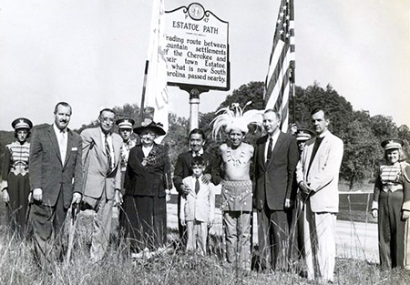
Estatoe Path was a long-established Indian trail that linked the eighteenth-century Cherokee Lower Towns of northwestern South Carolina and northeastern Georgia with the French Broad River Valley in western North Carolina. It may have originated at the site of Old Estatoe, located on a branch of the Upper Tugalo River near Clayton, Ga. However, it is more often described as originating with the cluster of Lower Towns, including Keowee and a different town of Estatoe on the Upper Keowee River in South Carolina. This path headed north, crossing into North Carolina's present-day Transylvania County to the vicinity of Rosman, where a large Cherokee town was apparently located. The path then followed the French Broad River Valley and ultimately reached the Toe River Valley. It is possible that the Mitchell County community of Estatoe derived its name from the nearby path.
Copyright Notice: This article is from the Encyclopedia of North Carolina edited by William S. Powell. Copyright © 2006 by the University of North Carolina Press. Used by permission of the publisher. For personal use and not for further distribution. Please submit permission requests for other use directly to the publisher.
Additional Resources:
"Estatoe Path." North Carolina Highway Historical Marker Program. https://www.ncdcr.gov/about/history/division-historical-resources/nc-highway-historical-marker-program/Markers.aspx?ct=ddl&sp=search&k=Markers&sv=P-47 (accessed October 18, 2012).
Williams, Marshall W. "The Estatoe Towns" Lamar Institute. 1970. http://shapiro.anthro.uga.edu/Lamar/images/PDFs/publication_142.pdf (accessed October 18, 2012).
Image Credits:
Transylvania Times. "Photograph, Accession #: H.1957.68.6." 1957. North Carolina Museum of History.
Citation
Moore, David G. "Estatoe Path." NCpedia. Encyclopedia of North Carolina, University of North Carolina Press. Accessed on December 14th, 2024. https://www.ncpedia.org/estatoe-path.