Governor: 1587-1590
See also: John White, Dictionary of North Carolina Biography
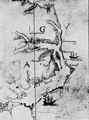
John White (born ca. 1540), artist, surveyor and cartographer, is best known as the governor of the second English expedition to Roanoke Island that ended in the ill-fated “Lost Colony.” He created an accurate map of the “Virginia” coast that was incorporated by other European mapmakers in their maps of North America and sketched the first drawings of the America’s natural life and natives, ones that outclass any other efforts at artistic portrayal of the New World. At one time, it was debated whether White the governor and White the artist were the same person, but historical evidence indicates that the governor and artist were indeed the same person.
White’s personal history prior to the Roanoke voyages is obscure, made more so by the fact that John White was such a common name. He was likely born in England possibly between 1540 and 1550 since he was a grandfather by 1587. White attended church in the parish of St. Martin Ludgate in London; he married Tomasyn Cooper in June 1566. The marriage produced two known children: Tom, who died as a young child, and Eleanor. White possibly was trained as an illustrator under a London master.
By the 1580s, White had become deeply involved with the English efforts to colonize North America. In 1585 White accompanied Sir Ralph Lane’s expedition to establish the first English colony in America. White served as the official artist and mapmaker for the expedition; he worked with scientist Thomas Harriot in recording flora and fauna and native people. In 1588 Harriot published A Briefe and True Report of the New Found Land of Virginia; it was not until Frankfort engraver and printer Theodor de Dry published Harriot’s book in 1590 that White’s images were reproduced. The book was published in four languages and attained wide attention in Europe.
Following the return of the all-male Lane colony, a new scheme emerged to establish another colony in Virginia. The new colony was to be settled with families and would be self-sustaining. The Chesapeake Bay area was the site selected for the colony. Sir Walter Raleigh, who held the land patent for Virginia, gave White the responsibility of organizing the effort. White spent late 1586 obtaining prospective settlers, in time securing 113 people. These included White’s daughter Eleanor and son-in-law Ananias Dare (who was also listed as one of White’s assistants). On January 7, 1587, a formal plan was established naming “John White of London Gentleman, to be the chief Governor there.”
The new colony left for Virginia in May 1587; they arrived at Roanoke Island in late July. The second colony at Roanoke repaired the building left from Lane’s colony and constructed new ones. White attempted to establish friendly relations with the Indians, but failed and tensions resulted. On a personal level, White became a grandfather following the birth of Virginia Dare the first English child born in North America, on August 18. The colonists’ situation soon became precarious. They arrived too late to plant crops, and the colonists could not depend on the Indians for help. With their supplies running low, the colonists asked White to return to England for supplies. White departed for England in late August and arrived in November.
White did not return to Roanoke until August 1590 because of various problems, including hostilities between England and Spain. In time, White arranged a relief expedition. However, when he and his party went ashore, they found no sign of life, but discovered that the colonists had constructed a fort. On an entrance post, the group found the word “CROATOAN” carved in it. The word was a predetermined signal that the colonists had gone to Croatoan, Manteo’s friendly Indian tribe. Poor weather conditions and a shortage of food and water forced White to give up the search for the colonists. White returned to England arriving in November 1590. The fate of the “Lost Colony” was never determined. The incident was a personal tragedy for White because he never again saw his daughter, son-in-law, or granddaughter.
Details of White’s life after Roanoke are virtually unknown. By February 1593 he resided in a house in County Cork, Ireland. Beyond this information nothing else survived. The date of his death has not been determined.