Stokes County Resources
- View All:
- Biographies
- Monuments
- locations
ANCHOR (A North Carolina History Online Resource) will soon have its own website!
We are setting up redirects so links to current ANCHOR pages on NCpedia will send users to the new site in the future.
Copyright Notice: This article is from the Encyclopedia of North Carolina edited by William S. Powell. Copyright © 2006 by the University of North Carolina Press. Used by permission of the publisher. For personal use and not for further distribution. Please submit permission requests for other use directly to the publisher.

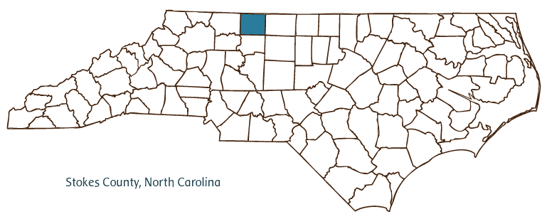
Stokes County, located in the Piedmont region of north central North Carolina, was formed in 1789 from Surry County and named for Capt. John Stokes, a Revolutionary War officer and a member of the North Carolina House of Commons. It is partially bordered by the state of Virginia. Early inhabitants of the area included the Saura (Cheraw) and other Siouan Indians; European settlers included the Scotch-Irish and the Moravians and other Germans. The county seat, Danbury, was named after a plantation belonging to Governor Alexander Martin; it was incorporated only in 1957, although it had been considered the county seat since 1849, when it replaced Germantown. Other Stokes County communities include King, Walnut Cove, Pinnacle, Gap, Lawsonville, Prestonville, and Meadows. Hanging Rock State Park is one of Stokes County's most popular natural destinations. Other notable physical features include the Dan and Yadkin Rivers, Beaverdam Creek, Hidden Falls, and Window Falls.
Among the historic sites and landmarks located in Stokes County are Historic Danbury, which preserves several fine examples of early twentieth-century architecture; Moratock Iron Furnace, built in 1843; the Rock House, the ruins of a two-story fieldstone structure built around 1770; and Sheppard's Mill, built in the early twentieth century. County cultural institutions include the Dan River Arts Market and the Stokes Art Council. The county hosts several festivals and annual events, such as the Stokes County Agricultural Fair, Kingfest, Festival on the Dan, King Christmas Parade, the Stokes County Craft Fair, and the Stokes Stomp.
Stokes County generates forest products and agricultural commodities such as tobacco, livestock, and corn. Manufactured products include copper tubing, elastic, cotton yarn, and medical equipment. The estimated population of Stokes County was just under 46,000 in 2004.
For an annotated history of the county's formation, with the laws affecting the county, boundary lines and changes, and other origin information, visit these references in The Formation of the North Carolina Counties (Corbitt, 2000), available online at North Carolina Digital Collections (note, there may be additional items of interest for the county not listed here):
County formation history: https://digital.ncdcr.gov/Documents/Detail/the-formation-of-the-north-ca...
Index entry for the county: https://digital.ncdcr.gov/Documents/Detail/the-formation-of-the-north-ca...
Additional resources:
Corbitt, David Leroy. 2000. The formation of the North Carolina counties, 1663-1943. https://digital.ncdcr.gov/Documents/Detail/the-formation-of-the-north-carolina-counties-1663-1943/3692099?item=4553233 (accessed June 20, 2017).
Stokes County Government: https://www.co.stokes.nc.us/
Stokes County Economic Development: www.stokesedc.com/wayoflife.aspx
Stokes County resources, NC Digital Heritage Center: https://www.digitalnc.org/counties/stokes-county/
North Carolina Digital Collections (explore by place, time period, format): https://digital.ncdcr.gov
Image credits:
Rudersdorf, Amy. 2010. "NC County Maps." Government & Heritage Library, State Library of North Carolina.
Mazzocchi, Jay. "Stokes County." NCpedia. State Library of NC. 2006. https://www.ncpedia.org/geography/stokes.