Surry County Resources
- View All:
- Biographies
- Monuments
- locations
ANCHOR (A North Carolina History Online Resource) is now its own website!
Copyright Notice: This article is from the Encyclopedia of North Carolina edited by William S. Powell. Copyright © 2006 by the University of North Carolina Press. Used by permission of the publisher. For personal use and not for further distribution. Please submit permission requests for other use directly to the publisher.
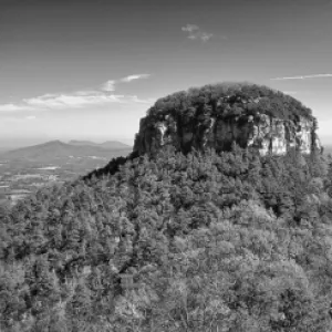
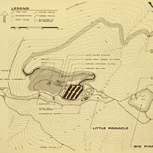
Surry County, located at the juncture of the Piedmont and Mountain regions of North Carolina and partially bordering the state of Virginia, was formed in 1771 from Rowan County and was named after either the English County of Surrey (birthplace of royal governor William Tryon) or the Saura (Cheraw) Indians who populated the area. Early inhabitants apart from the Saura were other Siouan Indians and the Cherokee, followed by English and German settlers. Dobson, the county seat, was incorporated in 1891 and was named for either William Dobson, a local justice of the peace in 1776, or William P. Dobson, a member of the General Assembly in 1814. Other communities in the county include Mount Airy, Level Cross, Ararat, Bottom, Elkin, and Toast. Pilot Mountain State Park is a much-visited natural site in Surry County, featuring a huge ancient quartzite stone monadnock visible for many miles. Flowing within Surry County are the Yadkin, Mitchell, and Ararat Rivers and numerous creeks, including Red Hill, Beaver, Toms, and Johnson. Mount Airy, "the Granite City," is home to the largest open-faced granite quarry in the world.
The original Siamese twins, Eng and Chang Bunker, are buried at White Plains Baptist Church. Notable among Surry County landmarks and historic sites is the downtown area of Mount Airy, Andy Griffith's hometown. The town boasts several structures connected to the fictional town of Mayberry in the Andy Griffith Show television series, including the Snappy Lunch, Old City Hall, Floyd's City Barber Shop, and the Andy Griffith Playhouse. Other cultural institutions include the Charles H. Stone Memorial Library, the Horne Creek Living Historical Farm, and the Foothills Theatre. The county hosts many festivals and annual events, such as the Surry County Agricultural Fair, the Autumn Leaves Festival, Mayberry Days, the Yadkin Valley Pumpkin Festival, and the Elkin Mid-Summer Invitational Tennis Tournament.
Surry County agricultural commodities include tobacco, corn, soybeans, strawberries, apples, swine, beef cattle, dairy products, sheep, and poultry. Manufactured products include hosiery, apparel, textiles, concrete blocks, polished granite, precision tools, blankets, and yarns. Mined in Surry County are minerals such as feldspar, quartz, and mica, in addition to granite. The population of the county was estimated at 72,200 in 2004.
For an annotated history of the county's formation, with the laws affecting the county, boundary lines and changes, and other origin information, visit these references in The Formation of the North Carolina Counties (Corbitt, 2000), available online at North Carolina Digital Collections (note, there may be additional items of interest for the county not listed here):
County formation history: https://digital.ncdcr.gov/Documents/Detail/the-formation-of-the-north-ca...
Index entry for the county: https://digital.ncdcr.gov/Documents/Detail/the-formation-of-the-north-ca...
Additional resources:
Corbitt, David Leroy. 2000. The formation of the North Carolina counties, 1663-1943. https://digital.ncdcr.gov/Documents/Detail/the-formation-of-the-north-carolina-counties-1663-1943/3692099?item=4553233 (accessed June 20, 2017).
Surry County Government: https://www.co.surry.nc.us/
Greater Mt. Airy Chamber of Commerce: https://www.mtairyncchamber.org/
DigitalNC, Surry County: https://www.digitalnc.org/counties/surry-county/
North Carolina Digital Collections (explore by place, time period, format): https://digital.ncdcr.gov
Image credits:
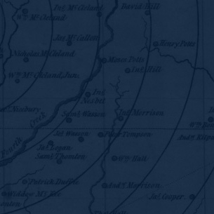
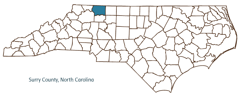
Rudersdorf, Amy. 2010. "NC County Maps." Government & Heritage Library, Library of North Carolina.
Mazzocchi, Jay. "Surry County." NCpedia. Library of NC. 2006.
SURRY COUNTY GOVERNMENT:
www.co.surry.nc.us
COUNTY SEAT: Dobson
FORMED: 1771
FORMED FROM: Rowan
LAND AREA: 532.17 square miles
2020 POPULATION ESTIMATE: 71,359
White: 92.9%
Black/African American: 4.2%
American Indian: 0.7%
Asian: 0.8%
Pacific Islander:0.1%
Two or more races: 1.3%
Hispanic/Latino: 11.1% (of any race)
From State & County QuickFacts, US Census Bureau, 2020.
CONGRESSIONAL DISTRICT: 5TH
BIOGRAPHIES FOR![]()
Surry County
 WILDLIFE PROFILES FOR
Mountain region
GEOGRAPHIC INFORMATION
REGION: Mountain, though technically some areas are in the Piedmont
RIVER BASIN: Roanoke, Yadkin-Pee Dee, Map
NEIGHBORING COUNTIES: Alleghany, Stokes, Wilkes, Yadkin