d. 23 May 1822
See also: Maps
Jonathan Price, cartographer, son of Benjamin Price, moved into Pasquotank County from an unknown location with his sister and brothers shortly after the beginning of the American Revolution. Price requested to come under the care of the Pasquotank Monthly Meeting of Friends in 1781 and was received as a member in 1785. He and his siblings seem to have been given little more than the rudiments of education but were taught useful trades. Mathematically gifted, Price was interested in geography, surveying, navigation, and astronomy and had leanings towards botany. His brother John was trained as a bricklayer, while Price himself was taught house carpentry in addition to, apparently, surveying. Though Price agreed in March 1785 to teach an apprentice, Joseph Newby, the craft of house carpentry, his real interest and career lay with the surveyor's chain and transit.
Price's first opportunity to put his surveying skills to regular use came in March 1789, when he was named Pasquotank County surveyor. This appointment coincided with his determination to produce a new map of the state based on actual surveys of its boundaries and coastal waters. Price envisioned the map as properly demarcating the counties; delineating the shoals, inlets, sounds, and estuaries with their depths; and correctly displaying the roads, ferries, and fords throughout the state. He commenced mapping the area embraced in Edenton District in 1789. By 1792 he had completed enough of his projected work to be able to exhibit it to the General Assembly. On 25 Dec. 1792 he petitioned the Assembly for assistance in financing the work. At the same time, Nathaniel Christmas, who had returned from northern Georgia to Orange County, appeared with a similar petition and sample of his work. The Assembly agreed in January 1793 to lend Price £500 for three years. Of this sum, Price and Christmas, having agreed upon a collaboration, jointly borrowed £290 in October 1793 and began work on a map of the state.
At about this time Price came to the attention of John Gray Blount, presumably through Blount's brother Thomas, who had been in the Assembly when Price's petition was presented. Blount required the services of surveyors capable of integrating a multitude of surveys into a single comprehensive plan and of projecting numerous entries of land into a single tract covered by one survey. Price had done precisely this when laying out, as Pasquotank County surveyor, the forty land entries totaling 26,000 acres in Dismal Swamp belonging to a Blount rival, John Hamilton. Price gave up his office of county surveyor in 1794 for far more lucrative employment by the Blount family. John Gray Blount recognized Price's gifts as a topographic surveyor and encouraged him in the production of his new map of the state. When Price and Christmas finished their version of the map in 1795, the Blounts looked into the matter of getting it engraved for them in Philadelphia. It is extremely unlikely that this version was based on actual surveys of the entire state or that it satisfied the ideal described to the General Assembly by Price in 1792. More probably it was based in part on actual surveys, but in greater part on compilation of data projected cartographically.
Price abandoned the 1795 version of the map after meeting John Strother, a second topographic surveyor employed by Blount. Strother shared Price's conception of a map truly based on actual surveys in which every feature would be laid down with the precision of a surveyor's plat. The two agreed to join their talents to produce such a map. Under authority of the 1793 resolution, Price borrowed another £300 from the state treasurer in September 1795 (though he should have been allowed only £210). Presumably he took this sum for the purpose for which it had been authorized—completion of the state map. One supposes he found another way of financing the project later in 1795 with the publication of his Description of Occacock Inlet. This eight-page portolano was published at New Bern by François X. Martin and included Price's chart to illustrate his sailing directions engraved by William Johnston, a local silversmith. When, in December, Strother heard that Price had had a piece of work published, he leapt to the conclusion that Price had stolen a march and had published under his name alone some of their joint work. This misunderstanding was easily cleared up. It was not until 1798 that their joint work began to appear.
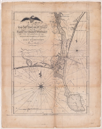
When Price was ready to publish the chart of the coastal survey he had made with Strother, he turned once more to William Johnston of New Bern to engrave the plates. When the chart came out in 1798, it was issued in two sheets, each measuring 14 by 23 inches, and carried the title, "To Navigators This Chart, Being an Actual Survey of the Sea Coast and Inland Navigation from Cape Henry to Cape Roman, is most Respectfully Inscribed by Price and Strother." A second chart meant specifically for the use of Cape Fear merchants was engraved for Price by William Barker of Philadelphia and published as a 13 7/8- by 18 3/4 -inch "Map of the Cape Fear River and Its Vicinity from the Frying Pan Shoals to Wilmington by Actual Survey, Addressed to the Commissioners of Navigation of Port Wilmington by Price and Strother." This chart was so satisfactory that Joshua Potts, a leading merchant of Wilmington, had it reengraved in a reduced version by John Scoles of New York and used it as a business card in his correspondence with European merchants. (Scoles, however, omitted the names of Price and Strother as authors of the chart.)
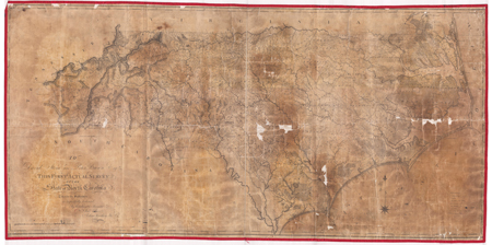
Work on the survey of the state progressed apace. Early in 1796 Price and Strother copyrighted it. After completing rough maps of nearly two-thirds of the state at a cost of $3,000, they successfully petitioned the General Assembly at the end of 1796 for an additional loan of £500. They announced forthcoming publication of, and opened subscriptions to, the map in June 1797. In December 1798 (when Strother had completed all the surveys he had engaged to prepare), the two men approached the Assembly for a further loan, having already borrowed £1,090 from the state. After the Assembly rose, a number of prominent members, including Blake Baker, David Stone, and William Richardson Davie, offered to advance, on the credit of expected sales, a loan of $1,000 towards engraving and publishing the map. In the end, the balance of cash needed to pay the engraver was put up by David Stone and Peter Browne, to whom the map is dedicated. (A final £100 loan was cadged out of the state treasurer by Price on 31 Dec. 1799.) In 1800 Price carried the final draft of the map to Philadelphia, where he remained from September until the spring of 1801 to oversee the engraving. When selecting an engraver for the chart of Cape Fear River, he had turned to one of the engravers employed by Matthew Carey in publishing his General Atlas. Now Price chose William Harrison, Jr., another engraver who was currently employed in that work. Harrison apparently engraved the manuscript just as it was given him, then pulled proofs for Price.
Sometime between Price's return to North Carolina in 1801 with the proofs and 1808 when the plates were corrected, Price, and perhaps others, read the map and marked engraver and author errors. William Christmas might have read the map in proof for Price. His 1812 obituary makes the claim that Christmas was the chief person employed in drawing Price and Strother's map. One wonders if the statement is based on a confusion of the role, if any, Christmas might have played in the version of the map prepared by his brother Nathaniel and Price in 1795 with the role, if any, he played in the completion of the version by Strother and Price in 1799. Errors in the original drawing smack of the untutored Price rather than the better-educated Christmas: Roan for Rowan, Iredel for Iredell, Tyrrel for Tyrrell, Edgecomb for Edgecombe, Nap Reads for Knap of Reeds, and so forth. Corrections were made in the proof, including alterations in two oddities: both the name and the boundaries of John Gray Blount's home county, Beaufort, were omitted from the 1801 proof, and the name of Ashe County was corrected from "Davie." Corrections to the plates were not engraved until 1808, in which year it was published under the dedicatory title, "To David Stone and Peter Brown Esqrs. this First Actual Survey of the State of North Carolina[,] Taken by the Subscribers[,] is Respectfully Dedicated by their Humble Servants Jona. Price, John Strother." The map was favorably reviewed by Aiken's Atheneum (London) in August 1808 and announced for sale by booksellers before the end of the year. Copies of the 28 3/4 - by 59 1/4 -inch map intended for the subscribers might have been colored professionally in Philadelphia, but copies subsequently furnished local booksellers were colored by Price, who kept a stock of the unfinished engraved sheets on hand for that purpose.
Because the state lent £1,190 for the creation of the map, it is easy to forget that this was not a public work but was a private undertaking by an essentially untutored, though gifted, man. It was generally recognized that a new map of the state was much wanted, for the last authoritative map of North Carolina had been John Collet's 1770 publication, and there was very little reliable topographical knowledge of the state at the end of the century. It is a measure of Price's intellect that he could conceive of both so comprehensive an undertaking and the means of bringing it to fruition. It is a measure of his ability that he actually completed, with the assistance of Strother, the herculean task of surveying the entire state, sounding and charting its coast, and laying down with such precision its watercourses, roads, towns, meetinghouses, and country seats of principal landowners. Its publication was hailed by American and European reviewers. Price's debt to the state was eventually transferred to The University of North Carolina, whose trustees, having first sued for recovery of the outstanding portion of the £1,190 debt, eventually forgave Price the unpaid balance.
Between the completion and the publication of Price and Strother's map, the U.S. Congress authorized a survey in 1806 of the most dangerous part of the North Carolina coast—Cape Hatteras to Cape Fear. Thomas Blount, one of the state's delegation, was probably consulted by Secretary of the Treasury Albert Gallatin in the choice of surveyors to perform the task. Gallatin named Jonathan Price, Thomas Coles, and William Tatham commissioners for the survey. Of Coles nothing is known. Tatham, on the other hand, had been educated at Cambridge, had arrived in Virginia in 1769, and had been active in Tennessee affairs from 1776 to 1795, except for a stay in Robeson County, N.C., from 1784 to 1792. Of an eccentric mental poise, Tatham had gone to Spain on behalf of one of those flirtatious intrigues indulged in by various leaders from the western country—one of which had cost William Blount his political career in 1797. After having been declared persona non grata in 1796, Tatham had left Spain for England, where he had remained for nearly a decade. In 1805 he returned to the United States and sought employment in Washington, D.C. Here his personal feelings and ambitions received a "painful stab" from Thomas Blount, who appears to have been responsible for the naming of Price in the commission and to have thwarted Tatham's effort to have himself named chief surveyor by Gallatin. The Blounts' protection rendered Price safe from the schemes of Tatham, who proved a hindrance rather than a help in surveying the coast. Tatham attempted to persuade Price to replace Coles with a surveyor of Tatham's own choosing, he appears to have felt that his superior academic credentials outweighed Price's superior ability, he was quarrelsome, and he spent his time fribbling on the edges of the survey.
Price and Coles successfully completed the survey during the weeks from the end of May to the end of September 1806 despite Tatham, tempestuous weather, and a hurricane that sank the two cutters used by them and destroyed Coles's papers, notes, and instruments. Their succinct narrative report was accompanied by a 24 3/4 - by 35-inch manuscript, "Chart of the Coast of North Carolina between Cape Hatteras & Cape Fear From a Survey taken in the Year 1806 by Thomas Coles and Jonathan Price Pursuant to Act of Congress." (The chart was engraved for publication, and copies were offered for sale by North Carolina booksellers, though there are no known surviving examples of the engraved chart.) The draftsmanship of the manuscript chart forwarded to Secretary Gallatin, drawn to a scale of seven miles to the inch, exceeds Price's skill, though he is said to have understood drawing very well. It must have been drawn by someone whose talents had been given the necessary technical training: perhaps Thomas Coles, or the New Bern engraver William Johnston, or the architect William Nichols (whom Tatham had wished to engage as clerk to the survey). At the end of the survey, Price, perfectly capable of speaking his mind, relieved his feelings by expressing rather too freely his opinion of Tatham. This, too, must have been a "painful stab" to Tatham. He brought suit against Price, asking £1,000 damages. The jury found Price's words to have been actionable but meticulously fixed the damage to Tatham's reputation not at £1,000 but at precisely £37/10. Tatham, himself, to his credit as a gentleman, prevented the judgment from actually being executed against Price.
Price's next major surveys of a public nature were on behalf of the state. (He had been a member of the 1796–1803 commission to locate and mark the North Carolina–South Carolina boundary that never had been able to arrange a meeting with its South Carolina counterpart.) In 1815 the General Assembly, having been finally awakened to the necessity of giving its attention to internal improvements, erected a Board of Commissioners to Superintend Public Works. Price's patron, Peter Browne, was one of the commissioners, and when Price applied for the execution of some of the proposed public surveys, he was in 1818 awarded a contract for half the six surveys under consideration by the board. The commissioners especially wished to find a means of opening a direct communication from Roanoke River to Ocracoke Inlet; to concentrate the trade of Roanoke, Tar-Pamlico, and Neuse rivers at one place; and to open a communication from Neuse River to Beaufort Inlet. They were similarly anxious to improve the navigation of the Cape Fear and Yadkin rivers. The commissioners gave to Price as an assistant Woodson Clements (d. 1837), a young surveyor and later sheriff of Wake County, and sent them to examine the possibility of uniting the Uwharrie and Deep rivers by a navigable canal.
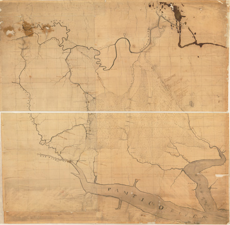
To this end Price and Clements ascertained the relative levels of the two rivers and explored the watercourses in the two river systems. The result was Price's manuscript topographic survey measuring 24 1/5 by 28 1/2 inches, "Plans and Sections of the Uwharee [sic ] and Deep Rivers," completed in July 1818 (now hanging in the library of the executive mansion). From here, Price and Clements were sent by the commissioners to the northeastern section of the state, where they made four surveys: the country between the Roanoke and Tar rivers by a route from Conoho Creek to Tranters Creek, the country between the Pamlico and Roanoke rivers from the town of Washington to the mouth of Smithwick Creek, the country between Roanoke River at Plymouth to the head of navigation on Pungo River, and the country between the Pamlico and Neuse rivers by a route from Blounts Creek to Swift Creek. Though the text of Price and Clements's reports of their four surveys was published by the state printer in 1818 and again in the 1839 report of the Board of Internal Improvements, only one of the four manuscript maps of the project is known to have survived: the 35 2/5- by 35 3/5-inch survey of the country between Roanoke and Pungo rivers (in the North Carolina State Archives).
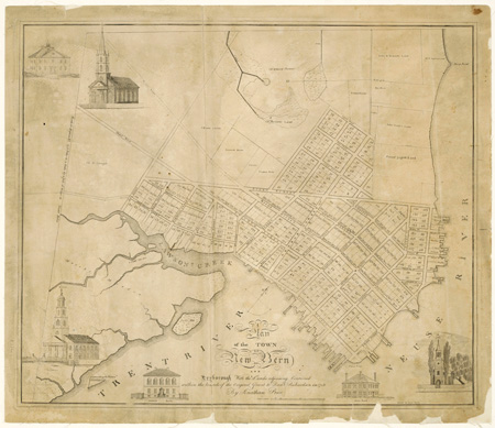
Price's other publicly commissioned works were undertaken on behalf of municipalities. The commissioners of New Bern, where he had moved from Pasquotank County, employed Price in 1809 to resurvey the town and renew the cornerstones of the squares. A few years later he combined this survey with one of 1806 that had laid out lots and streets on the property of the Dry family lying to the north of the town beyond Queen Street. The result was published about 1817 or shortly thereafter as "A Plan of the Town of New Bern and Dryborough With the Lands adjoining Contained within the bounds of the Original Grant to Danl. Richardson in 1713." Engraved by Allen Fitch, the 19 1/4- by 23-inch town plan was embellished with views of New Bern Academy, the Bank of New Bern, the State Bank of North Carolina, and the original building of Christ Church. After Price's death in 1822 his administrator, Joseph Bell, purchased the plate for ten dollars and had it further engraved with additional views of the recently completed Presbyterian church (1822) and the new Christ Church (1824). From the altered plates Bell struck fresh impressions. Of the original and second state of Price's plan of New Bern, neither of which bears a date, it is the post-1824 printing that is usually seen.
Between the date of Price's survey of New Bern and its publication, he was engaged by the commissioners of Beaufort to resurvey that town in May 1816. As late as 1951 his 21- by 32-inch manuscript plan of Beaufort was still being used by the corporation as the basis for town engineering work. Simultaneously with this survey, Price was employed to lay off the squares and streets of Lenoxville, a new town proposed to be established east of Beaufort. Never published, the original of Price's 12- by 16-inch manuscript plan of Lenoxville was given to the North Carolina Collection at Chapel Hill in 1958.
In his religious life Price remained active in Quaker affairs only from 1781 to 1797, but he seems to have embraced some of their principles permanently. In politics he was a Jeffersonian and unsuccessfully stood for election to the 1799 General Assembly. Intellectually his broad-ranging interests were reminiscent of the philosophes, though he shared neither their materialism nor their hedonism. In his private conversation he met opposing opinion with temper and candor, but without acrimony or malice. The overriding characteristic of his life is said to have been a true philanthropic benevolence. He took the people he enslaved to Philadelphia and freed them, then visited them later in life and assured himself of their well-being. In his death he serves as a reminder of the caution, "Be careful what you pray for—you may get it." When the Presbyterians of New Bern announced their intention in 1818 of building a church in the town, Price jested that he had no wish to live any longer than until the Presbyterians, said to be too poor or too mean to build, completed the structure. His death followed the completion of the church by four months. Price appears to have been long predeceased by his wife, Susannah Morris, and their three children, Mary, Miriam, and Samuel.