Nash County Resources
- View All:
- Biographies
- Monuments
- locations
ANCHOR (A North Carolina History Online Resource) is now its own website!
Copyright Notice: This article is from the Encyclopedia of North Carolina edited by William S. Powell. Copyright © 2006 by the University of North Carolina Press. Used by permission of the publisher. For personal use and not for further distribution. Please submit permission requests for other use directly to the publisher.

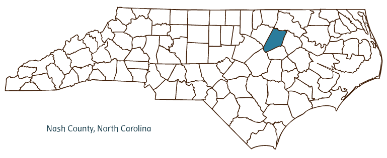
Nash County, located on the border of the Coastal Plain and Piedmont regions of North Carolina, was formed in 1777 from Edgecombe County and named for Revolutionary War general Francis Nash, who died at the Battle of Germantown. Early inhabitants of the area included the Tuscarora Indians, followed by English and Irish settlers. The county seat, Nashville, was named for the county and incorporated in 1815. Nash County shares the towns of Rocky Mount, Whitakers, and Sharpsburg with adjacent counties; communities wholly within Nash County include Spring Hope, Bailey, Stanhope, Castalia, and Momeyer. The county's notable physical features include the Tar River, White Oak Swamp, and Moccasin, Swift, and Deer Branch Creeks.
Nash County farmers produce agricultural commodities such as tobacco, sweet potatoes, cucumbers, soybeans, corn, peanuts, cotton, beef and dairy cattle, and poultry. The county's manufactured products include diesel engines, electronic fuel control systems, textiles, apparel, and pharmaceuticals. The second textile mill in the state, Rocky Mount Mills, was established in 1818 and operated until the end of the twentieth century. Minerals such as gold and iron are mined in the county.
North Carolina Wesleyan College was incorporated in Rocky Mount in 1956 and opened in 1960. Nash County landmarks include the first Hardee's restaurant (1960) and the China American Tobacco Company Factory, built in 1919. Cultural institutions include the Country Doctor Museum, the Playhouse Community Theatre, the Tank Theatre, and the Nash County Historical Association. Nash County hosts several festivals and annual events, including the Outdoor Art Show, the Nashville Blooming Festival, the Spring Hope Pumpkin Festival, and the Freedom Celebration. Nash County's population stood at an estimated 90,700 in 2004.
For an annotated history of the county's formation, with the laws affecting the county, boundary lines and changes, and other origin information, visit these references in The Formation of the North Carolina Counties (Corbitt, 2000), available online at North Carolina Digital Collections (note, there may be additional items of interest for the county not listed here):
County formation history: https://digital.ncdcr.gov/Documents/Detail/the-formation-of-the-north-ca...
Index entry for the county: https://digital.ncdcr.gov/Documents/Detail/the-formation-of-the-north-ca...
References:
Richard L. Mattson, History and Architecture of Nash County, North Carolina (1987).
Additional resources:
Corbitt, David Leroy. 2000. The formation of the North Carolina counties, 1663-1943. https://digital.ncdcr.gov/Documents/Detail/the-formation-of-the-north-carolina-counties-1663-1943/3692099?item=4553233 (accessed June 20, 2017).
Nash County Government: https://nashcountync.gov/
Nashville Chamber of Commerce: https://nashvillencchamber.org/
Rocky Mount Area Chamber of Commerce: https://www.rockymountchamber.org/
DigitalNC, Nash County: https://www.digitalnc.org/counties/nash-county/
Nash County Historical Association Collection, 1806-1928. Southern Historical Collection, University of North Carolina Chapel Hill: https://www.lib.unc.edu/mss/inv/n/Nash_County_Historical_Association.html
North Carolina Digital Collections (explore by place, time period, format): https://digital.ncdcr.gov
Image credits:
Rudersdorf, Amy. 2010. "NC County Maps." Government & Heritage Library, State Library of North Carolina.
Mazzocchi, Jay. "Nash County." NCpedia. State Library of NC. 2006. https://www.ncpedia.org/geography/nash.