Union County Resources
- View All:
- Biographies
- Monuments
- locations
ANCHOR (A North Carolina History Online Resource) is now its own website!
Copyright Notice: This article is from the Encyclopedia of North Carolina edited by William S. Powell. Copyright © 2006 by the University of North Carolina Press. Used by permission of the publisher. For personal use and not for further distribution. Please submit permission requests for other use directly to the publisher.
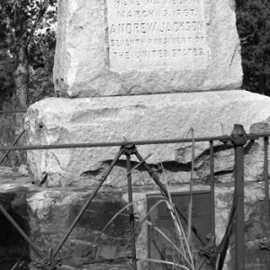
See also: Andrew Jackson Birthplace.
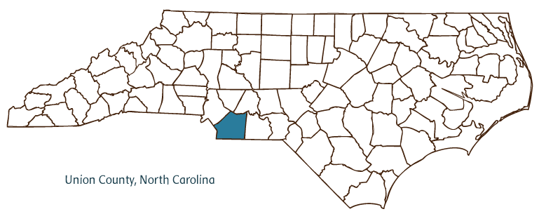
Union County, located in the Piedmont region of North Carolina, was formed in 1842 from Mecklenburg and Anson Counties. Democrats wanted to name it for one of their leaders (Andrew Jackson) and Whigs for one of theirs (Henry Clay), so "Union" was chosen as a compromise. It is situated along the South Carolina border. Early inhabitants of the area included the Waxhaw and Catawba Indians; German, Scotch-Irish, English, and Welsh settlers followed. Monroe, the county seat, was incorporated in 1844 and named for President James Monroe. Other communities in the county include Weddington, Indian Trail, Stallings, Wingate, Marvin, Lake Park, New Salem, Marshville, and Fairview. Union County's notable physical features include the Rocky River, Lake Twiddy, Lee Branch, and Richardson and Beaverdam Creeks.
President Andrew Jackson was born in the Waxhaws area on the border of North Carolina and South Carolina, and both states claim to be his authentic birthplace. Union County maintains the Museum of the Waxhaws and Andrew Jackson Memorial to honor Jackson. Wingate University was established in Wingate (near Monroe) in 1896. Union County landmarks and historic sites include the Old Union Courthouse, built in 1886; the Confederate Memorial, erected in 1910; and the North Corner Boundary Stone, dated to 1818. Cultural institutions include the Union County Heritage Room; the Jesse Helms Center, an educational institution promoting free enterprise and other values championed by the Monroe native and longtime U.S. senator; the Rainbow Theatre; and the Waxhaw Historical Festival and Drama Association. The county hosts popular festivals and annual events such as the Waxhaw Scottish Fair and Games, the Blooming Arts Festival in Monroe, the Marshville Boll Weevil Festival, and the Weddington Fall Festival.
Part of the fast-growing Charlotte metropolitan area, Union County experienced rapid growth in the late twentieth century. By 2004 it had an estimated population of 151,800. Despite increased urbanization, agriculture remains vital to parts of Union County. Its agricultural goods include soybeans, grains, cotton, eggs, dairy products, poultry, and hogs. Manufactured products include industrial pumps, furniture, textile machinery, and plastic containers.
For an annotated history of the county's formation, with the laws affecting the county, boundary lines and changes, and other origin information, visit these references in The Formation of the North Carolina Counties (Corbitt, 2000), available online at North Carolina Digital Collections (note, there may be additional items of interest for the county not listed here):
County formation history: https://digital.ncdcr.gov/Documents/Detail/the-formation-of-the-north-ca...
Index entry for the county: https://digital.ncdcr.gov/Documents/Detail/the-formation-of-the-north-ca...
References:
Kendrick, Virginia A. S., ed. The Heritage of Union County, North Carolina. Monroe: Carolinas Genealogical Society, 1993.
Additional resources:
Corbitt, David Leroy. The Formation of the North Carolina Counties, 1663-1943. Raleigh: Division of Archives and History, North Carolina Department of Cultural Resources, 1987. https://digital.ncdcr.gov/Documents/Detail/the-formation-of-the-north-carolina-counties-1663-1943/3692099?item=4553233 (accessed June 20, 2017).
Union County Government. https://www.unioncountync.gov/ (accessed February 15, 2019).
Union County Chamber of Commerce. "Welcome tot he Union County Chamber." https://www.unioncountycoc.com (accessed February 15, 2019).
DigitalNC. "Union County." North Carolina Digital Heritage Center. https://www.digitalnc.org/counties/union-county/ (accessed February 15, 2019).
North Carolina Digital Collections. "Explore by ... [place, time period, format]." North Carolina Department of Natural and Cultural Resources. https://digital.ncdcr.gov (accessed February 15, 2019).
Image credits:
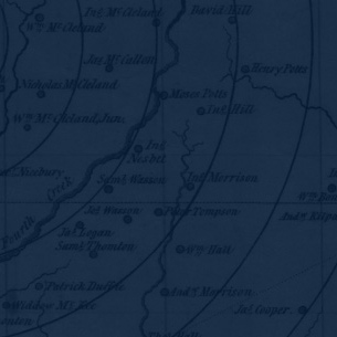
Rudersdorf, Amy. "NC County Maps." Raleigh: Government & Heritage Library, Library of North Carolina, 2010.
Powell, William S. "Union County." NCpedia. Library of NC. June 2022.
UNION COUNTY GOVERNMENT:
www.co.union.nc.us
COUNTY SEAT: Monroe
FORMED: 1842
FORMED FROM: Anson, Mecklenburg
LAND AREA: 631.52 square miles
2020 POPULATION ESTIMATE: 238,267
White: 81.1%
Black/African American: 12.5%
American Indian: 0.6%
Asian: 3.6%
Pacific Islander: 0.1%
Two or more races: 2.0%
Hispanic/Latino: 11.5% (of any race)
From State & County QuickFacts, US Census Bureau, 2020.
CONGRESSIONAL DISTRICT: 9TH
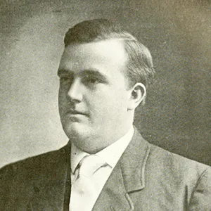
BIOGRAPHIES FOR![]()
Union County
 WILDLIFE PROFILES FOR
Piedmont region
GEOGRAPHIC INFORMATION
REGION: Piedmont
RIVER BASIN: Catawba, Yadkin-Pee Dee, Map
NEIGHBORING COUNTIES: Anson, Cabarrus, Mecklenburg, Stanly