Pitt County Resources
- View All:
- Biographies
- Monuments
- locations
ANCHOR (A North Carolina History Online Resource) is now its own website!
Copyright Notice: This article is from the Encyclopedia of North Carolina edited by William S. Powell. Copyright © 2006 by the University of North Carolina Press. Used by permission of the publisher. For personal use and not for further distribution. Please submit permission requests for other use directly to the publisher.

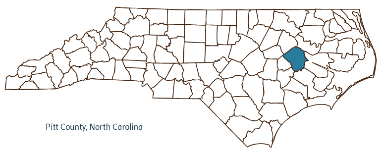
Pitt County, located in the Coastal Plain region of eastern North Carolina, was formed in 1760 from Beaufort County and named for William Pitt, earl of Chatham. Early inhabitants of the area included the Tuscarora Indians, followed by English and Welsh settlers. The site of Catechna, a fortified Tuscarora town and the site of a siege by Col. John "Jack" Barnwell and his troops in April 1712, is north of Grifton. Greenville, the county seat, was incorporated in 1771 as Martinsborough, named for North Carolina's last royal governor, Josiah Martin; in 1786, the name was changed to Greenville in honor of Revolutionary general Nathanael Greene. Other Pitt County communities include Ayden, Bethel, Simpson, Black Jack, Calico, and Toddy. Notable among the physical features of the county are the Tar River, Clayroot Swamp, Pinelog Branch, Grindle Creek, Pea Branch, and Lake Kristi.
East Carolina University (founded in 1907 as the East Carolina Teachers Training School), located in Greenville, has a tremendous cultural and economic influence on the county. Pitt County historic structures include several buildings on the East Carolina campus as well as the Pitt County Courthouse (1910-11). Non-university-related cultural institutions include the Greenville Museum of Art, the Nature Science Center, Ayden's Art and Recreation Center, the Dance Arts Theatre, and the Adventures in Health Children's Museum. The county hosts annual events and festivals such as Winterville Watermelon Festival, the Farmville Dogwood Festival, and the Ayden Collard Festival.
Pitt County is a producer of tobacco, soybeans, grain, peanuts, vegetables, eggs, and swine and other livestock. County manufactures include textiles, pharmaceuticals, concrete products, and furnaces. Flooding of the Tar River as a result of Hurricane Floyd in 1999 caused more than $1.5 billion in damages to Pitt County communities and businesses. In 2004 the county's estimated population was 141,500.
For an annotated history of the county's formation, with the laws affecting the county, boundary lines and changes, and other origin information, visit these references in The Formation of the North Carolina Counties (Corbitt, 2000), available online at North Carolina Digital Collections (note, there may be additional items of interest for the county not listed here):
County formation history: https://digital.ncdcr.gov/Documents/Detail/the-formation-of-the-north-ca...
Index entry for the county: https://digital.ncdcr.gov/Documents/Detail/the-formation-of-the-north-ca...
Additional resources:
Corbitt, David Leroy. The Formation of the North Carolina Counties, 1663-1943. Raleigh: Division of Archives and History, North Carolina Department of Cultural Resources, 1987. https://digital.ncdcr.gov/Documents/Detail/the-formation-of-the-north-carolina-counties-1663-1943/3692099?item=4553233 (accessed June 20, 2017).
Pitt County Government. "Pitt County, North Carolina." https://www.pittcountync.gov/ (accessed February 15, 2019).
Greenville-Pitt County Chamber of Commerce. "Welcome to the Greenvill-Pitt County Chamber of Commerce." https://www.greenvillenc.org/ (accessed February 15, 2019).
DigitalNC. "Pitt County." North Carolina Digital Heritage Center. https://www.digitalnc.org/counties/pitt-county/ (accessed February 15, 2019).
North Carolina Digital Collections. "Explore by ... [place, time period, format]." North Carolina Department of Natural and Cultural Resources. https://digital.ncdcr.gov (accessed February 15, 2019).
Image credits:
Rudersdorf, Amy. "NC County Maps." Raleigh: Government & Heritage Library, State Library of North Carolina, 2010.
Mazzocchi, Jay. "Pitt County." NCpedia. State Library of NC. 2006. https://www.ncpedia.org/geography/pitt.